IMAGES TAKEN NEAR TO
Tullyard Road, OMAGH, BT78 4QA
Introduction
This page details the photographs taken nearby to Tullyard Road, BT78 4QA by members of the Geograph project.
The Geograph project started in 2005 with the aim of publishing, organising and preserving representative images for every square kilometre of Great Britain, Ireland and the Isle of Man.

There are currently over 7.5m images from over14,400 individuals and you can help contribute to the project by visiting https://www.geograph.org.uk
Image Map
Images are licensed for reuse under creativecommons.org/licenses/by-sa/2.0
Notes
- Clicking on the map will re-center to the selected point.
- The higher the marker number, the further away the image location is from the centre of the postcode.
Image Listing (6 Images Found)
Images are licensed for reuse under creativecommons.org/licenses/by-sa/2.0
Image
Details
Distance
1
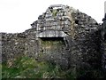
Ruined cottage, inside view
It seemed to have a single room with a neatly constructed hearth downstairs
There looks like a smaller opening above the main fireplace
Pictured here Image]
Image: © Kenneth Allen
Taken: 2 Dec 2013
0.08 miles
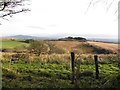
2
Tullyard Townland
The day is beginning to brighten up.
Image: © Kenneth Allen
Taken: 23 Jan 2006
0.08 miles
3
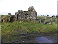
Ruined cottage, Tullyard
Pictured along Tullyard Road - see inside view Image]
Image: © Kenneth Allen
Taken: 2 Dec 2013
0.10 miles
4
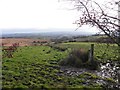
Tullyard Townland
Pictured along Tullyard Road
Image: © Kenneth Allen
Taken: 2 Dec 2013
0.11 miles
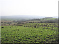
5
Tullyard Townland
Looking east from Tullyard Road
Image: © Kenneth Allen
Taken: 2 Dec 2013
0.18 miles
6
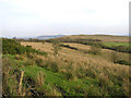
Kirlish Townland
A nice view of the countryside
Image: © Kenneth Allen
Taken: 23 Jan 2006
0.21 miles