IMAGES TAKEN NEAR TO
River Road, OMAGH, BT78 4LY
Introduction
This page details the photographs taken nearby to River Road, BT78 4LY by members of the Geograph project.
The Geograph project started in 2005 with the aim of publishing, organising and preserving representative images for every square kilometre of Great Britain, Ireland and the Isle of Man.

There are currently over 7.5m images from over14,400 individuals and you can help contribute to the project by visiting https://www.geograph.org.uk
Image Map
Images are licensed for reuse under creativecommons.org/licenses/by-sa/2.0
Notes
- Clicking on the map will re-center to the selected point.
- The higher the marker number, the further away the image location is from the centre of the postcode.
Image Listing (45 Images Found)
Images are licensed for reuse under creativecommons.org/licenses/by-sa/2.0
Image
Details
Distance
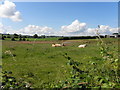
1
Cows, Kilstrule
Pictured along River Road
Image: © Kenneth Allen
Taken: 12 Apr 2017
0.03 miles
2
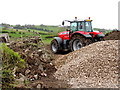
Tractor, Kilstrule
The contractor is taking a load of stones to fill into new drainage trenches in the field
Image: © Kenneth Allen
Taken: 24 Apr 2018
0.03 miles
3
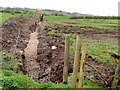
Installing field drainage, Kilstrule
Some areas of ground need this treatment
Image: © Kenneth Allen
Taken: 24 Apr 2018
0.04 miles
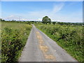
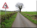
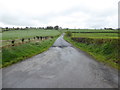
5
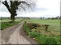
A bend ahead, Meaghy
Heading SSW on River Road
Image: © Kenneth Allen
Taken: 30 Jun 2014
0.05 miles
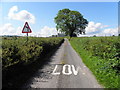
6
A sharp bend ahead, Kilstrule
Heading SSW on River Road
Image: © Kenneth Allen
Taken: 24 Apr 2018
0.05 miles
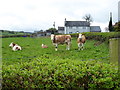
7
Cows, Meaghy
Pictured along River Road
Image: © Kenneth Allen
Taken: 30 Jun 2014
0.06 miles
9
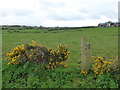
Whins, Kilstrule
Pictured along River Road
Image: © Kenneth Allen
Taken: 12 Apr 2017
0.07 miles