IMAGES TAKEN NEAR TO
Old Bridge Road, OMAGH, BT78 4JR
Introduction
This page details the photographs taken nearby to Old Bridge Road, BT78 4JR by members of the Geograph project.
The Geograph project started in 2005 with the aim of publishing, organising and preserving representative images for every square kilometre of Great Britain, Ireland and the Isle of Man.

There are currently over 7.5m images from over14,400 individuals and you can help contribute to the project by visiting https://www.geograph.org.uk
Image Map
Images are licensed for reuse under creativecommons.org/licenses/by-sa/2.0
Notes
- Clicking on the map will re-center to the selected point.
- The higher the marker number, the further away the image location is from the centre of the postcode.
Image Listing (2 Images Found)
Images are licensed for reuse under creativecommons.org/licenses/by-sa/2.0
Image
Details
Distance
1
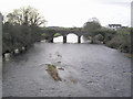
The old bridge at Millbrook
It is located between Newtownstewart and Victoria Bridge and spans the river Derg which joins the main river Strule. It is build in stonework, the view was taken from the new bridge on the main road which runs parallel to it.
Image: © Kenneth Allen
Taken: 21 Dec 2005
0.06 miles
2
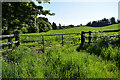
Milltown Townland
Looking east from Millbrook Road
Image: © Kenneth Allen
Taken: 20 May 2024
0.16 miles