IMAGES TAKEN NEAR TO
Grouse Park Road, OMAGH, BT78 4JQ
Introduction
This page details the photographs taken nearby to Grouse Park Road, BT78 4JQ by members of the Geograph project.
The Geograph project started in 2005 with the aim of publishing, organising and preserving representative images for every square kilometre of Great Britain, Ireland and the Isle of Man.

There are currently over 7.5m images from over14,400 individuals and you can help contribute to the project by visiting https://www.geograph.org.uk
Image Map
Images are licensed for reuse under creativecommons.org/licenses/by-sa/2.0
Notes
- Clicking on the map will re-center to the selected point.
- The higher the marker number, the further away the image location is from the centre of the postcode.
Image Listing (52 Images Found)
Images are licensed for reuse under creativecommons.org/licenses/by-sa/2.0
Image
Details
Distance
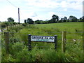
1
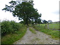
Lane, Lislap West
Pictured along Grouse Park Road
Image: © Kenneth Allen
Taken: 14 Aug 2014
0.04 miles
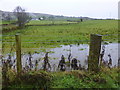
2
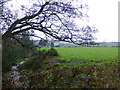
Wet along Castletown Road, Lislap West
Pictured along Castletown Road
Image: © Kenneth Allen
Taken: 23 Dec 2014
0.07 miles
3
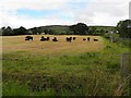
Cattle, Lislap West
Pictured along the Castletown Road
Image: © Kenneth Allen
Taken: 24 Jun 2010
0.08 miles
4
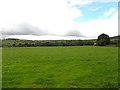
Lislap West
Looking south towards Legacurry
Image: © Kenneth Allen
Taken: 24 Jun 2010
0.09 miles
5
Lislap West Townland
Looking south from Grouse Park Road
Image: © Kenneth Allen
Taken: 14 Aug 2014
0.10 miles
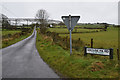
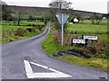
6
Grouse Park Road, Lislap
Heading west from Castletown Road
I have already mentioned somewhere else that there is another road sign wrongly placed here
Image: © Kenneth Allen
Taken: 14 Aug 2014
0.10 miles
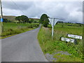
7
Grouse Park Road
Heading east towards Castletown Road
Image: © Kenneth Allen
Taken: 14 Aug 2014
0.10 miles
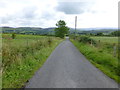
8
Grouse Park Road, Lislap West
Heading west from Castletown Road
Image: © Kenneth Allen
Taken: 29 Jan 2020
0.11 miles
9
Grouse Park Road, Lislap West
That rouge name sign for Gortgranagh Road is still there
Possibly nabbed from here? Image]
Image: © Kenneth Allen
Taken: 26 Nov 2013
0.11 miles
10
Flooded ground, Lislap West
Pictured along Castletown Road
Image: © Kenneth Allen
Taken: 23 Dec 2014
0.11 miles