IMAGES TAKEN NEAR TO
Honeyford Lane, OMAGH, BT78 4JN
Introduction
This page details the photographs taken nearby to Honeyford Lane, BT78 4JN by members of the Geograph project.
The Geograph project started in 2005 with the aim of publishing, organising and preserving representative images for every square kilometre of Great Britain, Ireland and the Isle of Man.

There are currently over 7.5m images from over14,400 individuals and you can help contribute to the project by visiting https://www.geograph.org.uk
Image Map
Images are licensed for reuse under creativecommons.org/licenses/by-sa/2.0
Notes
- Clicking on the map will re-center to the selected point.
- The higher the marker number, the further away the image location is from the centre of the postcode.
Image Listing (25 Images Found)
Images are licensed for reuse under creativecommons.org/licenses/by-sa/2.0
Image
Details
Distance
1

Mural, Newtownstewart
Pictured along Oldcastle Road
Image: © Kenneth Allen
Taken: 26 Feb 2024
0.14 miles
2
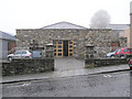
St Mary's Oratory Newtownstewart
Located at Dublin Road, opposite the Library; see interior view Image]
Image: © Kenneth Allen
Taken: 22 Nov 2005
0.19 miles
3
Glen Road, Newtownstewart
Heading west from Dublin Street
Image: © Kenneth Allen
Taken: 2 Dec 2021
0.19 miles
4

DS Dairy Siupplise Ltd, Newtownstewart
It is located along Old Castle Road
Image: © Kenneth Allen
Taken: 14 Aug 2014
0.20 miles
5
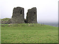
Harry Avery's Castle, Newtownstewart, Co. Tyrone
A curiously enigmatic castle named after and possibly built by Henry Aimbreidh O'Neill, a Gaelic chief celebrated by the Four Masters for his justice, nobility and hospitality who died in 1392. The castle commands wide views over the Mourne Valley and is unusual in being a stone-built stronghold located deep in the heart of pre-Plantation Ulster. It consists of a two-storey rectangular block fronted by a pair of massive D-shaped towers - resembling a gatehouse - projecting from the south face of an artificially scarped knoll, whose sides have been revetted by a wall to form a polygonal enclosure, now ruined to a low level with traces of a latrine tower on the north side. Excavations in 1950 and 1962 confirmed that the keep-like structure functioned more as a tower house than as a true gatehouse, though the only access into the enclosure behind seems to have been up a narrow mural stair and through the hall at first-floor level. The entrance has a draw-bar slot, while other features include vaults with traces of wickercentering and latrine shafts in one of the towers.
Image: © Kenneth Allen
Taken: 9 Dec 2005
0.21 miles
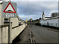
6
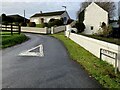
Sperrin View, Newtownstewart
Pictured along Old Castle Road
Image: © Kenneth Allen
Taken: 14 Aug 2014
0.21 miles
7
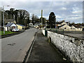
Old Castle Road, Newtownstewart
Heading WNW
Image: © Kenneth Allen
Taken: 26 Jan 2023
0.22 miles
9
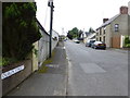
Dublin Street, Newtownstewart
Heading south
Image: © Kenneth Allen
Taken: 14 Aug 2014
0.22 miles
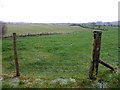
10
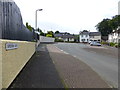
Road along Mourne Park, Newtownstewart
Heading north
Image: © Kenneth Allen
Taken: 26 Jan 2023
0.22 miles