IMAGES TAKEN NEAR TO
Lough Road, OMAGH, BT78 4HH
Introduction
This page details the photographs taken nearby to Lough Road, BT78 4HH by members of the Geograph project.
The Geograph project started in 2005 with the aim of publishing, organising and preserving representative images for every square kilometre of Great Britain, Ireland and the Isle of Man.

There are currently over 7.5m images from over14,400 individuals and you can help contribute to the project by visiting https://www.geograph.org.uk
Image Map
Images are licensed for reuse under creativecommons.org/licenses/by-sa/2.0
Notes
- Clicking on the map will re-center to the selected point.
- The higher the marker number, the further away the image location is from the centre of the postcode.
Image Listing (30 Images Found)
Images are licensed for reuse under creativecommons.org/licenses/by-sa/2.0
Image
Details
Distance
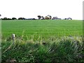
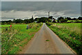
2
Drumlegagh Townland
Looking north-east
Image: © Kenneth Allen
Taken: 25 Aug 2011
0.05 miles
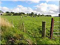
3
Bull, Drumlegagh
Glad to see it behind a gate
Image: © Kenneth Allen
Taken: 24 Oct 2017
0.07 miles
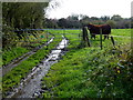
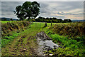
5
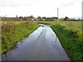
Flooding along Lough Road
Heading north at Drumlegagh
Image: © Kenneth Allen
Taken: 24 Oct 2017
0.08 miles
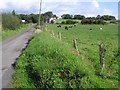
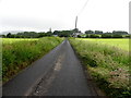
6
Lough Road
Heading north at Drumlegagh
Image: © Kenneth Allen
Taken: 21 Sep 2022
0.08 miles
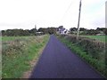
7
Lough Road
Heading north at Drumlegagh
Image: © Kenneth Allen
Taken: 21 Jun 2016
0.09 miles
9
Muddy entrance to field, Drumlegagh
Pictured along Lough Road
Image: © Kenneth Allen
Taken: 21 Sep 2022
0.10 miles
10
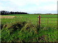
Drumlegagh Townland
Looking west from Lough Road
Image: © Kenneth Allen
Taken: 24 Oct 2017
0.12 miles