IMAGES TAKEN NEAR TO
Drumlegagh Church Road, OMAGH, BT78 4HG
Introduction
This page details the photographs taken nearby to Drumlegagh Church Road, BT78 4HG by members of the Geograph project.
The Geograph project started in 2005 with the aim of publishing, organising and preserving representative images for every square kilometre of Great Britain, Ireland and the Isle of Man.

There are currently over 7.5m images from over14,400 individuals and you can help contribute to the project by visiting https://www.geograph.org.uk
Image Map
Images are licensed for reuse under creativecommons.org/licenses/by-sa/2.0
Notes
- Clicking on the map will re-center to the selected point.
- The higher the marker number, the further away the image location is from the centre of the postcode.
Image Listing (4 Images Found)
Images are licensed for reuse under creativecommons.org/licenses/by-sa/2.0
Image
Details
Distance
2

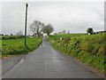
Killmore-Robinson Townland
Looking at the green fields
Image: © Kenneth Allen
Taken: 23 Jan 2006
0.15 miles
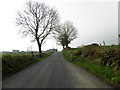
3
Powering up the hill, Drumlegagh
Heading SSW along Drumlegagh Church Road
See view from here Image]
Image: © Kenneth Allen
Taken: 31 Mar 2014
0.20 miles
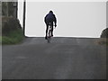
4
Drumlegagh Church Road, Drumlegagh
Looking SSW - a cyclist on the horizon is heading up the hill towards Drumlegagh
See close-up here Image]
Image: © Kenneth Allen
Taken: 31 Mar 2014
0.22 miles