IMAGES TAKEN NEAR TO
Baronscourt Road, OMAGH, BT78 4EX
Introduction
This page details the photographs taken nearby to Baronscourt Road, BT78 4EX by members of the Geograph project.
The Geograph project started in 2005 with the aim of publishing, organising and preserving representative images for every square kilometre of Great Britain, Ireland and the Isle of Man.

There are currently over 7.5m images from over14,400 individuals and you can help contribute to the project by visiting https://www.geograph.org.uk
Image Map
Images are licensed for reuse under creativecommons.org/licenses/by-sa/2.0
Notes
- Clicking on the map will re-center to the selected point.
- The higher the marker number, the further away the image location is from the centre of the postcode.
Image Listing (17 Images Found)
Images are licensed for reuse under creativecommons.org/licenses/by-sa/2.0
Image
Details
Distance
1
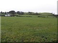
Middle Deerpark
Looking south from Baronscourt Road
Image: © Kenneth Allen
Taken: 26 Nov 2013
0.06 miles
2

Middle Deerpark, Newtownstewart
Pictured along the Baronscourt Road
Image: © Kenneth Allen
Taken: 19 Aug 2009
0.09 miles
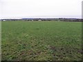
3

Middle Deerpark
Looking south-west near Newtownstewart
Image: © Kenneth Allen
Taken: 19 Aug 2009
0.11 miles
4

Baronscourt Road, Newtownstewart
Heading west
Image: © Kenneth Allen
Taken: 19 Aug 2009
0.14 miles
5
Baronscourt Road
Heading east towards Newtownstewart at Middle Deerpark
Image: © Kenneth Allen
Taken: 26 Nov 2013
0.14 miles
6
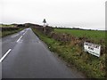
Baronscourt Road, Middle Deerpark
Heading west towards Baronscourt / Newtownstewart Golf Club
The school sign is the wrong way round
Image: © Kenneth Allen
Taken: 26 Nov 2013
0.15 miles
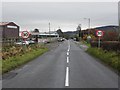
8
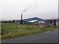
Factory, Newtownstewart
Pictured along Baronscourt Road
Image: © Kenneth Allen
Taken: 26 Nov 2013
0.18 miles
9
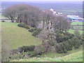
Rath at Newtownstewart, County Tyrone
A view from Harry Avery's castle
Image: © Kenneth Allen
Taken: 9 Dec 2005
0.18 miles
