IMAGES TAKEN NEAR TO
Tievemore Road, OMAGH, BT78 3RP
Introduction
This page details the photographs taken nearby to Tievemore Road, BT78 3RP by members of the Geograph project.
The Geograph project started in 2005 with the aim of publishing, organising and preserving representative images for every square kilometre of Great Britain, Ireland and the Isle of Man.

There are currently over 7.5m images from over14,400 individuals and you can help contribute to the project by visiting https://www.geograph.org.uk
Image Map
Images are licensed for reuse under creativecommons.org/licenses/by-sa/2.0
Notes
- Clicking on the map will re-center to the selected point.
- The higher the marker number, the further away the image location is from the centre of the postcode.
Image Listing (27 Images Found)
Images are licensed for reuse under creativecommons.org/licenses/by-sa/2.0
Image
Details
Distance
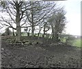
1
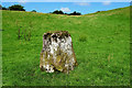
Standing stone, Lisnahanna
In the Northern Ireland Sites & Monuments website it is described as follows:
At the bottom of a marshy, interdrumlin hollow. Another standing stone is located nearby to N, but cannot be seen from here. This is a fine, small stone of limestone, roughly square in section, with sides 0.6m x 0.6m x 0.65m x 0.7m & standing 1.1m high. It has no definite orientation.
Image: © Kenneth Allen
Taken: 8 Aug 2020
0.10 miles
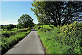
2
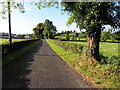
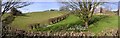
Tievemore Road
Heading SSW from Lisnahanna to Lougherush
Image: © Kenneth Allen
Taken: 7 Oct 2015
0.11 miles
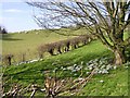
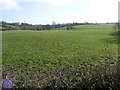
3
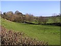
Corlea Townland
A small river runs through.
Image: © Kenneth Allen
Taken: 20 Feb 2007
0.12 miles
4
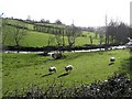
Sheep at Corlea
As ever always curious when they see someone approach.
Image: © Kenneth Allen
Taken: 20 Feb 2007
0.12 miles
6
Corlea Townland
The clumps of snowdrops made a nice scene.
Image: © Kenneth Allen
Taken: 20 Feb 2007
0.12 miles
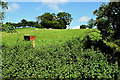
8
Rath at Stranagummer
As seen from the side of the road.
Image: © Kenneth Allen
Taken: 20 Feb 2007
0.14 miles
9
Tievemore Road, Lisnahanna
Heading SSW
Image: © Kenneth Allen
Taken: 8 Aug 2020
0.17 miles
10
Kilskeery Townland
Taken just outside the village. In the very distance is Brougher Mountain.
Image: © Kenneth Allen
Taken: 20 Feb 2007
0.18 miles