IMAGES TAKEN NEAR TO
Gargadis Road, OMAGH, BT78 3NX
Introduction
This page details the photographs taken nearby to Gargadis Road, BT78 3NX by members of the Geograph project.
The Geograph project started in 2005 with the aim of publishing, organising and preserving representative images for every square kilometre of Great Britain, Ireland and the Isle of Man.

There are currently over 7.5m images from over14,400 individuals and you can help contribute to the project by visiting https://www.geograph.org.uk
Image Map
Images are licensed for reuse under creativecommons.org/licenses/by-sa/2.0
Notes
- Clicking on the map will re-center to the selected point.
- The higher the marker number, the further away the image location is from the centre of the postcode.
Image Listing (8 Images Found)
Images are licensed for reuse under creativecommons.org/licenses/by-sa/2.0
Image
Details
Distance
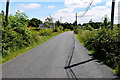
1
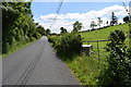
Gargadis Road, Dernagilly / Carran
Heading ESE towards Trillick
Image: © Kenneth Allen
Taken: 3 Jul 2019
0.07 miles
2
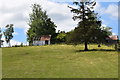
Ruined farm building, Carran
Looking south from Gargadis Road
Image: © Kenneth Allen
Taken: 3 Jul 2019
0.10 miles
3
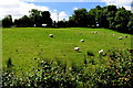
Sheep in a field, Carran
Pictured along Gargadis Road
Image: © Kenneth Allen
Taken: 3 Jul 2019
0.12 miles
4
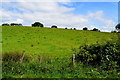
A low hill, Dernagilly
Pictured along Gargadis Road
Image: © Kenneth Allen
Taken: 3 Jul 2019
0.13 miles
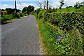
5
Gargadis Road, Dernagilly
Heading east
Image: © Kenneth Allen
Taken: 3 Jul 2019
0.14 miles
6
Gargadis Road
Heading WNW from Cavanamara towards Dernagilly
My attention was drawn to Image]
Image: © Kenneth Allen
Taken: 3 Jul 2019
0.18 miles
7
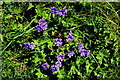
Geranium magnificum 'Rosemoor', along Gargadis Road
Escapee plants pictured here Image]
Image: © Kenneth Allen
Taken: 3 Jul 2019
0.19 miles
8
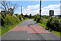
Approaching Trillick along Gargadis Road
Heading ESE at Cavanamars
Image: © Kenneth Allen
Taken: 3 Jul 2019
0.20 miles