IMAGES TAKEN NEAR TO
Moorfield Road, OMAGH, BT78 3LR
Introduction
This page details the photographs taken nearby to Moorfield Road, BT78 3LR by members of the Geograph project.
The Geograph project started in 2005 with the aim of publishing, organising and preserving representative images for every square kilometre of Great Britain, Ireland and the Isle of Man.

There are currently over 7.5m images from over14,400 individuals and you can help contribute to the project by visiting https://www.geograph.org.uk
Image Map
Images are licensed for reuse under creativecommons.org/licenses/by-sa/2.0
Notes
- Clicking on the map will re-center to the selected point.
- The higher the marker number, the further away the image location is from the centre of the postcode.
Image Listing (5 Images Found)
Images are licensed for reuse under creativecommons.org/licenses/by-sa/2.0
Image
Details
Distance
1
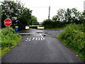
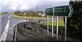
Doocrock Road, Ferney
The junction with Moorfield Road
Image: © Kenneth Allen
Taken: 21 Jul 2015
0.10 miles
2
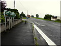
A32 Tummery Road
Heading south west at Stralongford
Image: © Kenneth Allen
Taken: 21 Jul 2015
0.23 miles
3
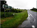
Tummery Road, Stralongford
Heading ENE towards Lisdoo
Image: © Kenneth Allen
Taken: 21 Jul 2015
0.23 miles
4
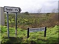
Moorfield Road, Stralongford
I have often noticed this sign for Tedd on the road from Dromore to Irvinestown. The only reference I can find to it on the map is Tedd crossroads.
Image: © Kenneth Allen
Taken: 27 Feb 2007
0.24 miles
5
Lisdoo
The road is heading south-east towards Omagh via Dromore.
Image: © Kenneth Allen
Taken: 27 Feb 2007
0.24 miles