IMAGES TAKEN NEAR TO
Gardrum Heights, OMAGH, BT78 3JE
Introduction
This page details the photographs taken nearby to Gardrum Heights, BT78 3JE by members of the Geograph project.
The Geograph project started in 2005 with the aim of publishing, organising and preserving representative images for every square kilometre of Great Britain, Ireland and the Isle of Man.

There are currently over 7.5m images from over14,400 individuals and you can help contribute to the project by visiting https://www.geograph.org.uk
Image Map
Images are licensed for reuse under creativecommons.org/licenses/by-sa/2.0
Notes
- Clicking on the map will re-center to the selected point.
- The higher the marker number, the further away the image location is from the centre of the postcode.
Image Listing (70 Images Found)
Images are licensed for reuse under creativecommons.org/licenses/by-sa/2.0
Image
Details
Distance
1
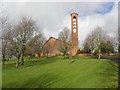
St Davog's RC Church, Dromore
It is located along Omagh Road, to the north-east of the town
A feature of the design is the bell tower with three ringing bells
It replaced the old church Image]
Image: © Kenneth Allen
Taken: 21 Feb 2011
0.08 miles
2
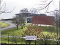
St John's College, Dromore
It is located along Omagh Road
Image: © Kenneth Allen
Taken: 21 Feb 2011
0.09 miles
3
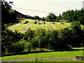
Graveyard at St. John's RC Church, Dromore
Pictured from Crawfords Lane
Image: © Kenneth Allen
Taken: 10 Jul 2013
0.10 miles
4
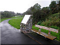
Seat and Information board, Dromore Riverside Park
See close-up of board here Image]
Image: © Kenneth Allen
Taken: 17 Sep 2011
0.13 miles
5
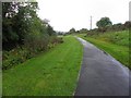
Dromore Riverside Walk
Looking south-west
Image: © Kenneth Allen
Taken: 17 Sep 2011
0.13 miles
6
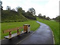
Seat and path, Dromore Riverside Walk
Looking north-east
Image: © Kenneth Allen
Taken: 17 Sep 2011
0.14 miles
7
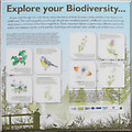
"Explore your Diversity" information board
The following text is included, "As you walk through this rural retreat, enjoy the chorus of birds, buzzing of bees and the scent of wildflowers. This walkway guides you through old and new woodland patches, wildflower meadows and small stream, a tributary of the Owenreagh River. These important habitats support many different species like spiders, bumblebees, beetles and butterflies, birds large and small and other wildlife such as field mice and bats.
Native woodlands have typically a mix of native trees such as ash, oak. birch, hazel and holly. Normally, an understorey of various smaller shrubs and plants such as bramble, dog rose, bluebell, red campion and dog-violet would grow, adding to the wildlife value of the woodland. Woodlands arc an important refuge for many species and vitally, they also gave people opportunities to get closer to nature. However in Northern Ireland, native woodlands only cover 1% of the land, making it by far the least wooded country in Europe. Take time to wander through the new and old woodland and see what you can discover.
Hay and wildflower meadows are a rare habitat in our local countryside as through the years farming practices have changed. It is thought that 97% of hay meadows have disappeared in Northern Ireland over the past 50 years. To increase the number of wildflowers growing here and help local wildlife, this park has been prepared with wildflowers and wild grass seed and will be managed as a meadow. As there are many different grasses and flowers in meadows, you will find a greater diversity of insects, like bees and butterflies. See what you can spot!"
Featured on the board are holly, blue tits, common dog-violet, meadow buttercup, ox-eye daisy, self heal, orange tip butterfly and the cuckoo flower.
Pictured here Image]
Image: © Kenneth Allen
Taken: 17 Sep 2011
0.14 miles
8
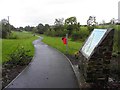
Path, Dromore Riverside Walk
Heading north-east
See information board here Image]
Image: © Kenneth Allen
Taken: 17 Sep 2011
0.15 miles
9
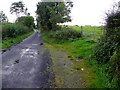
Crawfords Lane
Heading WSW towards Dromore
Image: © Kenneth Allen
Taken: 17 Sep 2011
0.15 miles
10
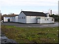
St Patrick's Hall, Dromore
It includes the famous Dromore Boxing Club
Image: © Kenneth Allen
Taken: 2 Dec 2008
0.15 miles