IMAGES TAKEN NEAR TO
Ashlands, OMAGH, BT78 3JD

Introduction

This page details the photographs taken nearby to Ashlands, BT78 3JD by members of the Geograph project.

The Geograph project started in 2005 with the aim of publishing, organising and preserving representative images for every square kilometre of Great Britain, Ireland and the Isle of Man.

There are currently over 7.5m images from over14,400 individuals and you can help contribute to the project by visiting https://www.geograph.org.uk

Image Map


Images are licensed for reuse under creativecommons.org/licenses/by-sa/2.0
Notes
  • Clicking on the map will re-center to the selected point.
  • The higher the marker number, the further away the image location is from the centre of the postcode.

Image Listing (21 Images Found)

Images are licensed for reuse under creativecommons.org/licenses/by-sa/2.0
  • ...
Image
Details
Distance
1
Crawfords Lane
Heading south-west - on the left is the entrance to Dromore Riverside Walk, one of the town's hidden gems.
Image: © Kenneth Allen Taken: 10 Jul 2013
0.03 miles
2
North entrance, Dromore Riverside Walk
Pictured along Crawfords Lane
Image: © Kenneth Allen Taken: 17 Sep 2011
0.05 miles
3
Dromore Presbyterian Church
It is located on the Omagh side of the town.
Image: © Kenneth Allen Taken: 30 Jan 2007
0.06 miles
4
Crawfords Lane, Drumconnis
Heading NNW from Omagh Road See nearby road sign here Image]
Image: © Kenneth Allen Taken: 10 Jul 2013
0.08 miles
5
Sign, Crawfords Lane
The road is nearby Image]
Image: © Kenneth Allen Taken: 10 Jul 2013
0.08 miles
6
Crawfords Lane, Gardrum
Heading ENE Included in the frame is Image] which is accessible from Omagh Road
Image: © Kenneth Allen Taken: 10 Jul 2013
0.09 miles
7
Dromore Riverside Walk
Looking south-east from Crawfords Lane
Image: © Kenneth Allen Taken: 17 Sep 2011
0.10 miles
8
Dromore Riverside Walk (north end)
See close-up of board here Image]
Image: © Kenneth Allen Taken: 17 Sep 2011
0.10 miles
9
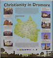
"Christianity in Dromore" information board
The following text is included, "The Parish of Dromore consists of some sixty townlands, ranging in size from little over a hundred acres to a thousand acres. The village sits in the centre of the parish and dates from the mid-eighteenth century. The parish as an entity is much older and there is strong evidence of an early Christian monastery in the townland of Kieldrum. The seventeenth century plantations introduced both Anglican and Presbyterian settlers to the locality. Methodism was also introduced here in the nineteenth century being based at Togherdoo in the Drumskinney / Galbaly district south of the village. In medieval political terms the Parish of Dromore was administered from Omagh and was part of the Barony of Omagh East. The poor law initiatives of the mid-nineteenth century placed most of Dromore Parish in the Union of Omagh with a few townlands in the south-west being part of the Union of Lowtherstown. The population of the parish reached its peak, with almost ten and a half thousand inhabitants, in 1841. Dromore suffered badly in the Great Hunger of the 1840s and the population fell rapidly due to famine deaths and heavy emigration. While many emigrants made their way to America, a very significant proportion of Dromore people made their homes in Australia, particularly in the New South Wales region." Included on the board are the Eye Well, Dromore Old Church, St. Dympna's Church, the Presbyterian Church, Togherdoo Church, the Dill tombstone, the Bell tower and Holy Trinity Church Pictured here Image]
Image: © Kenneth Allen Taken: 17 Sep 2011
0.10 miles
10
At Dromore
Looking north-west
Image: © Kenneth Allen Taken: 17 Sep 2011
0.12 miles
  • ...