IMAGES TAKEN NEAR TO
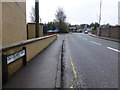
BT78 3FF
Introduction
This page details the photographs taken nearby to BT78 3FF by members of the Geograph project.
The Geograph project started in 2005 with the aim of publishing, organising and preserving representative images for every square kilometre of Great Britain, Ireland and the Isle of Man.

There are currently over 7.5m images from over14,400 individuals and you can help contribute to the project by visiting https://www.geograph.org.uk
Image Map
Images are licensed for reuse under creativecommons.org/licenses/by-sa/2.0
Notes
- Clicking on the map will re-center to the selected point.
- The higher the marker number, the further away the image location is from the centre of the postcode.
Image Listing (394 Images Found)
Images are licensed for reuse under creativecommons.org/licenses/by-sa/2.0
Image
Details
Distance
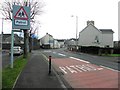
1

O'Neill Terrace, Dromore
Pictured along Omagh Road
Image: © Kenneth Allen
Taken: 9 Dec 2013
0.03 miles
2
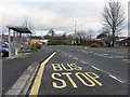
Bus stop, Old Creamery Road
By-passing Dromore village northwards
Image: © Kenneth Allen
Taken: 9 Dec 2013
0.05 miles
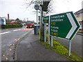
3

A32 Omagh Road, Dromore
Heading north-east towards Omagh
Image: © Kenneth Allen
Taken: 9 Dec 2013
0.05 miles
5
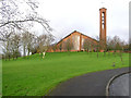
St John's RC Church, Dromore
It is located on the Omagh side of Dromore, County Tyrone. Opposite is a secondary school of the same name.
Image: © Kenneth Allen
Taken: 30 Dec 2005
0.05 miles
6
Old Creamery Road, Gardrum, Dromore
Heading SSE from Omagh Road
Image: © Kenneth Allen
Taken: 14 Dec 2016
0.05 miles
7

Old Creamery Road, Dromore
Heading north
Image: © Kenneth Allen
Taken: 14 Dec 2016
0.06 miles
8

St George's Terrace, Dormore
Heading NNW towards Trillick
Image: © Kenneth Allen
Taken: 2 Dec 2008
0.06 miles
9
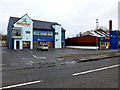
Revolution, Dromore
Pictured along Omagh Road
Image: © Kenneth Allen
Taken: 14 Dec 2016
0.06 miles