IMAGES TAKEN NEAR TO
Galbally Road, OMAGH, BT78 3EE
Introduction
This page details the photographs taken nearby to Galbally Road, BT78 3EE by members of the Geograph project.
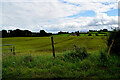
The Geograph project started in 2005 with the aim of publishing, organising and preserving representative images for every square kilometre of Great Britain, Ireland and the Isle of Man.

There are currently over 7.5m images from over14,400 individuals and you can help contribute to the project by visiting https://www.geograph.org.uk
Image Map
Images are licensed for reuse under creativecommons.org/licenses/by-sa/2.0
Notes
- Clicking on the map will re-center to the selected point.
- The higher the marker number, the further away the image location is from the centre of the postcode.
Image Listing (202 Images Found)
Images are licensed for reuse under creativecommons.org/licenses/by-sa/2.0
Image
Details
Distance
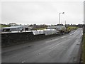
1
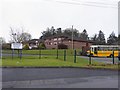
Dromore Primary School
It is located along Galbally Road
Image: © Kenneth Allen
Taken: 21 Feb 2011
0.05 miles
2
Shanmullagh Glebe
Pictured along Bridge Road
Image: © Kenneth Allen
Taken: 12 Mar 2013
0.09 miles
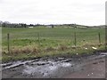
3
Fintona Road, Shanmullagh Glebe
Heading ENE towards Dromore
Image: © Kenneth Allen
Taken: 20 Sep 2013
0.09 miles
4
Shanmullagh Glebe
Looking west from Galbally Road
Image: © Kenneth Allen
Taken: 20 Sep 2013
0.10 miles
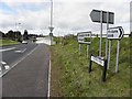
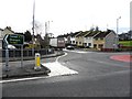
5
Galbally Road, Dromore
Looking east; on the left is Kenwell's store
Image: © Kenneth Allen
Taken: 21 Feb 2011
0.10 miles
6
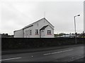
Orange Hall, Dromore
It is located along Galbally Road
Image: © Kenneth Allen
Taken: 21 Feb 2011
0.10 miles
7
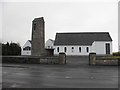
Holy Trinity Church of Ireland
It is located along Galbally Road
Image: © Kenneth Allen
Taken: 21 Feb 2011
0.10 miles
8
Galbally Road, Shanmullagh
Bending north-west to Dromore
Image: © Kenneth Allen
Taken: 20 Sep 2013
0.10 miles
9
Shanmullagh Glebe Townland
Looking east from Bridge Road
Image: © Kenneth Allen
Taken: 3 Aug 2024
0.12 miles
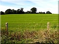
10
Fintona Road, Dromore
Heading south-east from the A32 Road
Image: © Kenneth Allen
Taken: 9 Dec 2013
0.12 miles