IMAGES TAKEN NEAR TO
Blackwater Road, OMAGH, BT78 3DG
Introduction
This page details the photographs taken nearby to Blackwater Road, BT78 3DG by members of the Geograph project.
The Geograph project started in 2005 with the aim of publishing, organising and preserving representative images for every square kilometre of Great Britain, Ireland and the Isle of Man.

There are currently over 7.5m images from over14,400 individuals and you can help contribute to the project by visiting https://www.geograph.org.uk
Image Map
Images are licensed for reuse under creativecommons.org/licenses/by-sa/2.0
Notes
- Clicking on the map will re-center to the selected point.
- The higher the marker number, the further away the image location is from the centre of the postcode.
Image Listing (17 Images Found)
Images are licensed for reuse under creativecommons.org/licenses/by-sa/2.0
Image
Details
Distance
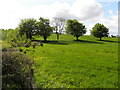
1
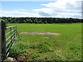
An open field, Longhill
Pictured along Owenreagh Road
Image: © Kenneth Allen
Taken: 17 Jun 2017
0.01 miles
2
Bridge along Blackwater Road
Heading north-west from Badoney to Dullaghan
Image: © Kenneth Allen
Taken: 3 Jun 2015
0.05 miles
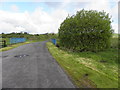
3
Rough ground, Badoney
Pictured along Blackwater Road
Image: © Kenneth Allen
Taken: 3 Jun 2015
0.10 miles
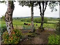
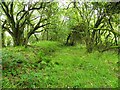
5
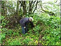
Interior of the rath at Bodoney (3)
This is the middle ring, which includes trees and there is evidence of a low level dry-stone wall, nearly a metre high in places
In the Northern Ireland Environment Agency website it states, "On top of a drumlin with extensive views all round. The interior, 23.6m N-S x 28m E-W is enclosed by a well preserved bank with internal stone revetting in places. It is 2m wide at the top, 1.3m high & 3m above the 1st ditch, which is 4.8m wide & 1m below the outer bank. It is 2.8m wide & 1.4m above the outer ditch, which in turn is 2.8m wide & 1m deep. There is an entrance at SW, 2m wide with a causeway over the ditch & a 2nd at E, which may be original & is 3m wide."
Image: © Kenneth Allen
Taken: 25 Jun 2011
0.13 miles
6
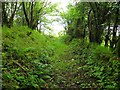
Interior of the rath at Bodoney (2)
Looking eastwards
Image: © Kenneth Allen
Taken: 25 Jun 2011
0.13 miles
7

Bridge at Bodoney
It spans a burn which joins the Owenreagh River.
Image: © Kenneth Allen
Taken: 7 Feb 2006
0.15 miles
8
Interior of the rath at Bodoney (4)
This is the central ditch between the inner ring and the elevated central mound
Pictured from here Image]
Image: © Kenneth Allen
Taken: 25 Jun 2011
0.16 miles
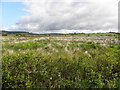
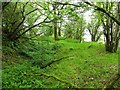
9
Trees, Badoney
Looking south-east from Blackwater Road
Image: © Kenneth Allen
Taken: 3 Jun 2015
0.16 miles
10
Interior of the rath at Bodoney (7)
Wellies were essential to tramp in round the site of the hill-fort as the ground was very much overgrown with all manor of plants. I was most grateful for the local farmer to let us in to look around, it was so relaxing to be able to be able to picture the site, despite the rainy conditions.
Image: © Kenneth Allen
Taken: 25 Jun 2011
0.18 miles