IMAGES TAKEN NEAR TO
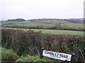
Corbally Road, OMAGH, BT78 2PD
Introduction
This page details the photographs taken nearby to Corbally Road, BT78 2PD by members of the Geograph project.
The Geograph project started in 2005 with the aim of publishing, organising and preserving representative images for every square kilometre of Great Britain, Ireland and the Isle of Man.

There are currently over 7.5m images from over14,400 individuals and you can help contribute to the project by visiting https://www.geograph.org.uk
Image Map
Images are licensed for reuse under creativecommons.org/licenses/by-sa/2.0
Notes
- Clicking on the map will re-center to the selected point.
- The higher the marker number, the further away the image location is from the centre of the postcode.
Image Listing (15 Images Found)
Images are licensed for reuse under creativecommons.org/licenses/by-sa/2.0
Image
Details
Distance
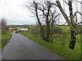
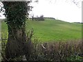
2
Syonfin Townland
Looking south from Corbally Road
Image: © Kenneth Allen
Taken: 22 Dec 2011
0.08 miles
3
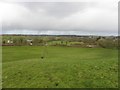
View from Syonfin hill fort
Looking north; I cloud see a rain sweeping down in the distance and reckoned it would be coming my way fairly soon, so I made my retreat back to the road and shelter.
Image: © Kenneth Allen
Taken: 23 Jan 2012
0.10 miles
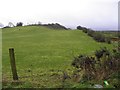
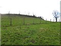
5
Hill fort, Syonfin
Looking SSW from Corbally Road
Image: © Kenneth Allen
Taken: 23 Jan 2012
0.14 miles
6
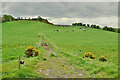
Cattle on a hillside, Syonfin
Pictured along Corbally Road
Image: © Kenneth Allen
Taken: 13 May 2021
0.16 miles
7
Pothole along Corbally Road
Pictured at Syonfin
Image: © Kenneth Allen
Taken: 13 May 2021
0.17 miles
9
Hill fort, Syonfin
Looking up the hill near the top
Image: © Kenneth Allen
Taken: 23 Jan 2012
0.19 miles
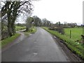
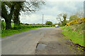
10
Dungoran Townland
A view from where the Syonee and Corbally roads meet.
Image: © Kenneth Allen
Taken: 26 Dec 2005
0.23 miles