IMAGES TAKEN NEAR TO
Lisdergan Road, OMAGH, BT78 2NS
Introduction
This page details the photographs taken nearby to Lisdergan Road, BT78 2NS by members of the Geograph project.
The Geograph project started in 2005 with the aim of publishing, organising and preserving representative images for every square kilometre of Great Britain, Ireland and the Isle of Man.

There are currently over 7.5m images from over14,400 individuals and you can help contribute to the project by visiting https://www.geograph.org.uk
Image Map
Images are licensed for reuse under creativecommons.org/licenses/by-sa/2.0
Notes
- Clicking on the map will re-center to the selected point.
- The higher the marker number, the further away the image location is from the centre of the postcode.
Image Listing (11 Images Found)
Images are licensed for reuse under creativecommons.org/licenses/by-sa/2.0
Image
Details
Distance
1
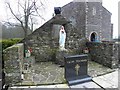
Shrine, St Lawrence's Church
It is located here Image]
Image: © Kenneth Allen
Taken: 17 Feb 2011
0.12 miles
2
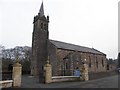
St Lawrence's RC Church
Looking north-east
See close-up of plaque here Image]
Image: © Kenneth Allen
Taken: 17 Feb 2011
0.12 miles
3
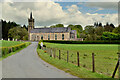
Lisdergan Road
Heading north from Lisnabulevey briefly into Stratigore
In the distance is St Lawrences Church which is located at Ecclesville Demesne, otherwise known as St Laurence the Martyr
Image: © Kenneth Allen
Taken: 13 May 2021
0.13 miles
4
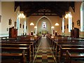
Interior, St Lawrence's Church
It is located here Image]
Image: © Kenneth Allen
Taken: 17 Feb 2011
0.13 miles
5
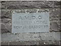
Plaque, St Lawrence's Church
The inscription includes the wording, "A M D C Erected AD1872 Reverend JA Cassidy PP"
It is located here Image]
Image: © Kenneth Allen
Taken: 17 Feb 2011
0.14 miles
6
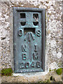
BM2046, St Lawrence's Church, Fintona
Flush bracket bench mark, it is located here Image
The number on the bracket is OSNIBM 2046.
The mark is 107.6 metres above MSL.
Image: © Kenneth Allen
Taken: 17 Feb 2011
0.14 miles
7
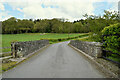
Bridge along Lisdergan Road
Heading ENE at Lisnabulevey
Image: © Kenneth Allen
Taken: 13 May 2021
0.16 miles
8
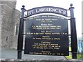
Information board, St Lawrence's Church
It is located here Image]
Image: © Kenneth Allen
Taken: 17 Feb 2011
0.17 miles
9
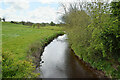
Quiggery Water, Lisnabulevey
Pictured along Lisdergan Road
Image: © Kenneth Allen
Taken: 13 May 2021
0.17 miles
10
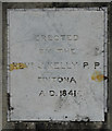
Plaque, St Lawrence's Church
Indicating that the church was erected in 1841 by Rev J Kell PP
It is located on the long wall Image]
Image: © Kenneth Allen
Taken: 17 Feb 2011
0.22 miles