IMAGES TAKEN NEAR TO
Edergoole Road, OMAGH, BT78 2NG
Introduction
This page details the photographs taken nearby to Edergoole Road, BT78 2NG by members of the Geograph project.
The Geograph project started in 2005 with the aim of publishing, organising and preserving representative images for every square kilometre of Great Britain, Ireland and the Isle of Man.

There are currently over 7.5m images from over14,400 individuals and you can help contribute to the project by visiting https://www.geograph.org.uk
Image Map
Images are licensed for reuse under creativecommons.org/licenses/by-sa/2.0
Notes
- Clicking on the map will re-center to the selected point.
- The higher the marker number, the further away the image location is from the centre of the postcode.
Image Listing (29 Images Found)
Images are licensed for reuse under creativecommons.org/licenses/by-sa/2.0
Image
Details
Distance
1
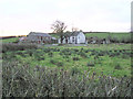
Sessiagh Townland, Fintons
A view from the Edergole Road
Image: © Kenneth Allen
Taken: 17 Dec 2005
0.02 miles
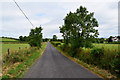
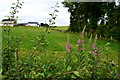
2

Drain, Mullanboy
Pictured along Edergole Road
Image: © Kenneth Allen
Taken: 14 Jan 2022
0.06 miles
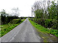
3

Edergole Road, Mullanboy
Heading south
Image: © Kenneth Allen
Taken: 14 Jan 2022
0.08 miles
4
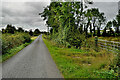
Edergole Road, Mullanboy
Heading south
Image: © Kenneth Allen
Taken: 9 Sep 2024
0.08 miles
5
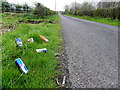
Debris along Edergole Road
People who do this don't think much of their wee country
See close-up here Image]
Image: © Kenneth Allen
Taken: 4 May 2015
0.08 miles
6

Mullanboy Townland
Pictured along Edergole Road
Image: © Kenneth Allen
Taken: 14 Jan 2022
0.10 miles
7
Edergole Road, Mullanboy
Heading north
Image: © Kenneth Allen
Taken: 13 Jul 2018
0.10 miles
8
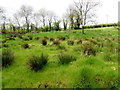
Rushes, Mullanboy
Pictured along Edergole Road
Image: © Kenneth Allen
Taken: 4 May 2015
0.10 miles
9
Mullanboy Townland
Looking west from Edergole Road
Image: © Kenneth Allen
Taken: 13 Jul 2018
0.11 miles
10
Edergole Road, Mullanboy
Heading south
Image: © Kenneth Allen
Taken: 4 May 2015
0.11 miles