IMAGES TAKEN NEAR TO
Drumhirk Road, OMAGH, BT78 2JU
Introduction
This page details the photographs taken nearby to Drumhirk Road, BT78 2JU by members of the Geograph project.
The Geograph project started in 2005 with the aim of publishing, organising and preserving representative images for every square kilometre of Great Britain, Ireland and the Isle of Man.

There are currently over 7.5m images from over14,400 individuals and you can help contribute to the project by visiting https://www.geograph.org.uk
Image Map
Images are licensed for reuse under creativecommons.org/licenses/by-sa/2.0
Notes
- Clicking on the map will re-center to the selected point.
- The higher the marker number, the further away the image location is from the centre of the postcode.
Image Listing (26 Images Found)
Images are licensed for reuse under creativecommons.org/licenses/by-sa/2.0
Image
Details
Distance
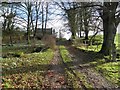
1
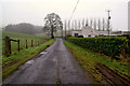
Misty along Drumhirk Road, Tattymoyle Middle
My attention was drawn to Image]
Image: © Kenneth Allen
Taken: 22 Jan 2020
0.01 miles
2
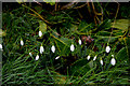
Snowdrops, Tattymoyle Middle
They're out already along the roadside here Image]
Image: © Kenneth Allen
Taken: 22 Jan 2020
0.01 miles
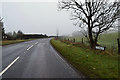
3
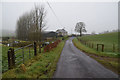
Drumhirk Road, Tattymoyle Middle
Heading NNW
Image: © Kenneth Allen
Taken: 22 Jan 2020
0.02 miles
4
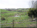
Crockanoun Townland
Rolling green hills..
Image: © Kenneth Allen
Taken: 16 Feb 2006
0.03 miles
5
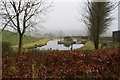
Pond, Tattymoyle Middle
Pictured along Drumhirk Road
Image: © Kenneth Allen
Taken: 22 Jan 2020
0.04 miles
6
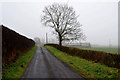
A tree in the mist, Tattymoyle Middle
Pictured along Drumhirk Road
Image: © Kenneth Allen
Taken: 22 Jan 2020
0.05 miles
7
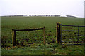
A low hill, Tattymoyle Middle
Pictured along Drumhirk Road
Image: © Kenneth Allen
Taken: 22 Jan 2020
0.05 miles
8
Tattymoyle Road, Tattymoyle Middle
Heading north-east from the junction with Drumhirk Road
Image: © Kenneth Allen
Taken: 22 Jan 2020
0.13 miles
9
Hidden farmhouse, Tattymoyle
Looking east
Image: © Kenneth Allen
Taken: 23 Jan 2012
0.15 miles
10
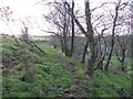
View along the front face of the rath, Tattymoyle
People used to think that these were "Fairy rings" and bad things could happen to you if you entered the area. There are paths that cross the sloping bank at several levels.
Pictured from here Image]
Image: © Kenneth Allen
Taken: 23 Jan 2012
0.16 miles