IMAGES TAKEN NEAR TO
Donacavey Road, OMAGH, BT78 2HR
Introduction
This page details the photographs taken nearby to Donacavey Road, BT78 2HR by members of the Geograph project.
The Geograph project started in 2005 with the aim of publishing, organising and preserving representative images for every square kilometre of Great Britain, Ireland and the Isle of Man.

There are currently over 7.5m images from over14,400 individuals and you can help contribute to the project by visiting https://www.geograph.org.uk
Image Map
Images are licensed for reuse under creativecommons.org/licenses/by-sa/2.0
Notes
- Clicking on the map will re-center to the selected point.
- The higher the marker number, the further away the image location is from the centre of the postcode.
Image Listing (5 Images Found)
Images are licensed for reuse under creativecommons.org/licenses/by-sa/2.0
Image
Details
Distance
1
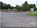
Carnalea Crossroads
Located outside Fintona with roads going to Omagh, Fintona, Fivemiletown and Seskanore
Image: © Kenneth Allen
Taken: 20 Sep 2005
0.14 miles
2
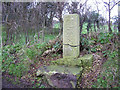
Carved stone, Donacavey
It is located on the laneway leading to the ancient graveyard at Donacavey, outside Fintona.
Image: © Kenneth Allen
Taken: 17 Dec 2005
0.15 miles
3
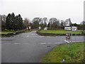
Carnalea Crossroads, Fintona
The intersection of the Carnalea Road and the Tattyreagh Road
Image: © Kenneth Allen
Taken: 12 Dec 2011
0.15 miles
4
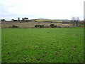
Eccles Green, Fintona
It is located on the road leading to the old Donacavey Graveyard.
Image: © Kenneth Allen
Taken: 17 Dec 2005
0.15 miles
5
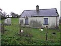
Ruined Cottage, Carnalea
Complete with outside toilet!
Image: © Kenneth Allen
Taken: 12 Dec 2011
0.19 miles