IMAGES TAKEN NEAR TO
Carnalea Road, OMAGH, BT78 1UH
Introduction
This page details the photographs taken nearby to Carnalea Road, BT78 1UH by members of the Geograph project.
The Geograph project started in 2005 with the aim of publishing, organising and preserving representative images for every square kilometre of Great Britain, Ireland and the Isle of Man.

There are currently over 7.5m images from over14,400 individuals and you can help contribute to the project by visiting https://www.geograph.org.uk
Image Map
Images are licensed for reuse under creativecommons.org/licenses/by-sa/2.0
Notes
- Clicking on the map will re-center to the selected point.
- The higher the marker number, the further away the image location is from the centre of the postcode.
Image Listing (203 Images Found)
Images are licensed for reuse under creativecommons.org/licenses/by-sa/2.0
Image
Details
Distance
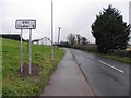
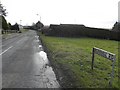
1
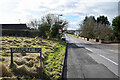
Carnalea Road, Seskinore
Heading south-west from Seskinore
Image: © Kenneth Allen
Taken: 16 Feb 2021
0.02 miles
2
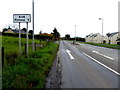
B46 Carnalea Road, Seskinore
Heading south-west
Image: © Kenneth Allen
Taken: 3 Nov 2017
0.02 miles
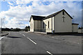
3
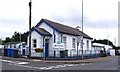
McClintock Primary School, Seskinore
It is located at the south end of the village. Originally known as Seskinore No.2 National School. It was built on a site donated by Lt. Col. John Knox McClintock who also largely subscribed to its construction. Building work began in 1900 and the school was completed in 1902. The No.2 school (so called because the first national school in the village was the Chapel School - now closed) had previously been located in a building opposite the Chapel gates (i.e. the RC Church, which was known as the Chapel) Other schools attended by pupils from the area include Garvallagh PS and St Lawrences PS in Fintona
Image: © Kenneth Allen
Taken: 6 Sep 2007
0.02 miles
4
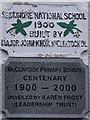
Plaque, Seskinore National School
Located here Image] and still going strong!
Image: © Kenneth Allen
Taken: 6 Sep 2007
0.02 miles
6
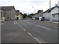
Seskinore, County Tyrone
Heading north-east to Omagh and Beragh. In the village, this is where The Tyrone Hunt (originally known as The Hunt) was founded by Lt. Col. George Perry McClintock in 1860. He was master until 1886 when he was succeeded by his second son, John Knox McClintock, who promptly changed to The Seskinore Harriers. The Hunt continued to meet until the early 1950s and was reformed in 1974 as Seskinore Pony Club.
Image: © Kenneth Allen
Taken: 6 Sep 2007
0.02 miles
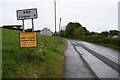
7
B83, Corkhill Road
Heading SSW towards Clogher
Image: © Kenneth Allen
Taken: 30 Jan 2012
0.02 miles
8
Corkhill Road, Seskinore
Heading SSW towards Clogher
Image: © Kenneth Allen
Taken: 29 May 2019
0.02 miles
9
Corkhill Road, Seskinore
Heading SSW towards Augher / Clogher
Image: © Kenneth Allen
Taken: 12 Feb 2011
0.02 miles
10
Main Street, Seskinore
Heading south-west to Carnalea Road
Included in the frame is the Catholic Church
Image: © Kenneth Allen
Taken: 16 Feb 2021
0.03 miles