IMAGES TAKEN NEAR TO
Ballynahatty Road, OMAGH, BT78 1QN
Introduction
This page details the photographs taken nearby to Ballynahatty Road, BT78 1QN by members of the Geograph project.
The Geograph project started in 2005 with the aim of publishing, organising and preserving representative images for every square kilometre of Great Britain, Ireland and the Isle of Man.

There are currently over 7.5m images from over14,400 individuals and you can help contribute to the project by visiting https://www.geograph.org.uk
Image Map
Images are licensed for reuse under creativecommons.org/licenses/by-sa/2.0
Notes
- Clicking on the map will re-center to the selected point.
- The higher the marker number, the further away the image location is from the centre of the postcode.
Image Listing (107 Images Found)
Images are licensed for reuse under creativecommons.org/licenses/by-sa/2.0
Image
Details
Distance
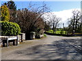
1
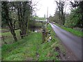
Ballynahatty Road, Edergoole
Heading WSW over Ballynahatty Water
Image: © Kenneth Allen
Taken: 28 Feb 2012
0.01 miles
2
Ballynahatty Road, Edergole Upper
Heading north-east
Image: © Kenneth Allen
Taken: 18 May 2021
0.02 miles
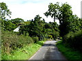
3
Bend along Ballynahatty Road
Heading WSW from the junction with Edergole Road
Image: © Kenneth Allen
Taken: 18 May 2021
0.02 miles
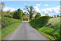
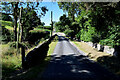
4
Ballynahatty Road
Heading east at Edergole Upper
The gable wall of the old manse can be seen among the trees on the left
Image: © Kenneth Allen
Taken: 8 Sep 2017
0.02 miles
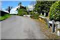
5
Ballynahatty Road, Edergole Upper
Edergole Avenue is to the right
Image: © Kenneth Allen
Taken: 20 Apr 2018
0.02 miles
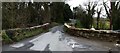
6
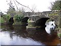
Ballynahatty Bridge, Edergoole
Note the first arch on the left is wider than the rest; it is almost as if it was started to make the road wide enough for two way traffic but the rest of the sections were altered to make it to carry a single lane across the Owenreagh River
Image: © Kenneth Allen
Taken: 28 Feb 2012
0.03 miles
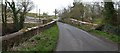
7
Ballynahatty Bridge
Heading WSW on Ballynahatty from Ballynahatty to Edergole Upper
Image: © Kenneth Allen
Taken: 11 Aug 2022
0.03 miles
8
Ballynahatty Bridge
Looking south-west on the Ballynahatty Road, Edergole Avenue is to the left. Nearby is "Castle Hill" as it is referred to by the locals, in which there was a castle built but all traces of it have gone. The dimensions have been recorded by historians too but there is no indication of its location on the map. Re-cycling is nothing new as it is believed that the stones were re-used in some local constructions like Ballynahatty Bridge and surrounding farm buildings.
Image: © Kenneth Allen
Taken: 1 Apr 2008
0.03 miles
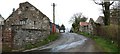
9
Ballynahatty Bridge
Looking north-east along the Ballynahatty Road. This narrow bridge over the Ballynahaty Water was privately built in by-gone times and had been a toll-bridge initially.
Image: © Kenneth Allen
Taken: 1 Apr 2008
0.03 miles
10
Ballynahatty road
Heading north before going up the hill and round the corner. Part of the old school remains to the right hand side of the road.
Image: © Kenneth Allen
Taken: 1 Apr 2008
0.03 miles