IMAGES TAKEN NEAR TO
Coolnagard Brae, OMAGH, BT78 1GB
Introduction
This page details the photographs taken nearby to Coolnagard Brae, BT78 1GB by members of the Geograph project.
The Geograph project started in 2005 with the aim of publishing, organising and preserving representative images for every square kilometre of Great Britain, Ireland and the Isle of Man.

There are currently over 7.5m images from over14,400 individuals and you can help contribute to the project by visiting https://www.geograph.org.uk
Image Map
Images are licensed for reuse under creativecommons.org/licenses/by-sa/2.0
Notes
- Clicking on the map will re-center to the selected point.
- The higher the marker number, the further away the image location is from the centre of the postcode.
Image Listing (3 Images Found)
Images are licensed for reuse under creativecommons.org/licenses/by-sa/2.0
Image
Details
Distance
1
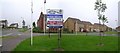
Coolnagard Village, Omagh
One of the more recent housing developments, this sign describes it as a village and it includes Coolnagard View, Coolnagard Close, Coolnagard Gardens and Coolnagard Grove. If it is anything like where I live, the postman is bound to get mixed up with the variant addresses. It is located off the new roundabout on the Kevlin Road.
Image: © Kenneth Allen
Taken: 4 Aug 2006
0.24 miles
2
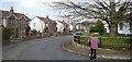
Cannonhill, Omagh
It wasn't as nice as this when we lived here. There is a sharp turn up the corner on the right which was quite a challenge when we had more severe winters. It required a race with the car to get up the hill. If you went too fast, you could go too far into the bend and come off the road.
Image: © Kenneth Allen
Taken: 24 Mar 2007
0.24 miles
3
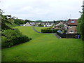
Open grassed area, Kevlin Gardens
Looking west from Kevlin Road
Image: © Kenneth Allen
Taken: 20 Jun 2013
0.25 miles