IMAGES TAKEN NEAR TO
Dunroe Road, AUGHER, BT77 0EB
Introduction
This page details the photographs taken nearby to Dunroe Road, BT77 0EB by members of the Geograph project.
The Geograph project started in 2005 with the aim of publishing, organising and preserving representative images for every square kilometre of Great Britain, Ireland and the Isle of Man.

There are currently over 7.5m images from over14,400 individuals and you can help contribute to the project by visiting https://www.geograph.org.uk
Image Map
Images are licensed for reuse under creativecommons.org/licenses/by-sa/2.0
Notes
- Clicking on the map will re-center to the selected point.
- The higher the marker number, the further away the image location is from the centre of the postcode.
Image Listing (3 Images Found)
Images are licensed for reuse under creativecommons.org/licenses/by-sa/2.0
Image
Details
Distance
1
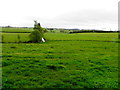
Sessia Townland
Looking south-east from Dunroe Road in the direction of Mullans
Image: © Kenneth Allen
Taken: 2 Jun 2015
0.10 miles
3
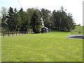
Rath at Mullans, Augher
It is behind a grassed area at the rear of a new bungalow
Image: © Kenneth Allen
Taken: 21 Apr 2006
0.23 miles