IMAGES TAKEN NEAR TO
Crossowen Road, AUGHER, BT77 0AX
Introduction
This page details the photographs taken nearby to Crossowen Road, BT77 0AX by members of the Geograph project.
The Geograph project started in 2005 with the aim of publishing, organising and preserving representative images for every square kilometre of Great Britain, Ireland and the Isle of Man.

There are currently over 7.5m images from over14,400 individuals and you can help contribute to the project by visiting https://www.geograph.org.uk
Image Map
Images are licensed for reuse under creativecommons.org/licenses/by-sa/2.0
Notes
- Clicking on the map will re-center to the selected point.
- The higher the marker number, the further away the image location is from the centre of the postcode.
Image Listing (12 Images Found)
Images are licensed for reuse under creativecommons.org/licenses/by-sa/2.0
Image
Details
Distance
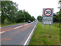
1
A4 at Augher Tenements
Heading south-west to Clogher
Image: © Kenneth Allen
Taken: 17 Jun 2013
0.06 miles
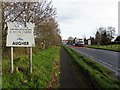
2
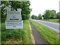
Augher sign
Pictured along the A4 in the Borough of Dungannon and South Tryone
Image: © Kenneth Allen
Taken: 17 Jun 2013
0.07 miles
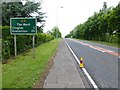
3
Crossowen Road, Augher
Heading north-east towards the village
Image: © Kenneth Allen
Taken: 17 Jun 2013
0.09 miles
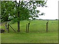
4
Augher Tenements Townland
Looking north-west
Hidden from view is Augher Lake, with Augher Castle beyond
Image: © Kenneth Allen
Taken: 17 Jun 2013
0.10 miles
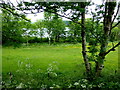
5
Field, Augher Tenements
Looking south-east
Image: © Kenneth Allen
Taken: 17 Jun 2013
0.10 miles
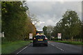
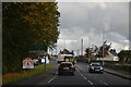
8
Approaching Augher from Clogher
Pictured along the A4
Image: © Kenneth Allen
Taken: 16 Nov 2010
0.14 miles
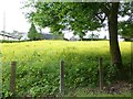
9
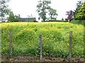
Field with buttercups, Augher
Looking south-east
Image: © Kenneth Allen
Taken: 17 Jun 2013
0.15 miles