IMAGES TAKEN NEAR TO
Aghintain Road, CLOGHER, BT76 0UY
Introduction
This page details the photographs taken nearby to Aghintain Road, BT76 0UY by members of the Geograph project.
The Geograph project started in 2005 with the aim of publishing, organising and preserving representative images for every square kilometre of Great Britain, Ireland and the Isle of Man.

There are currently over 7.5m images from over14,400 individuals and you can help contribute to the project by visiting https://www.geograph.org.uk
Image Map
Images are licensed for reuse under creativecommons.org/licenses/by-sa/2.0
Notes
- Clicking on the map will re-center to the selected point.
- The higher the marker number, the further away the image location is from the centre of the postcode.
Image Listing (20 Images Found)
Images are licensed for reuse under creativecommons.org/licenses/by-sa/2.0
Image
Details
Distance
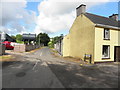
1

Former Post Office, Townagh
Pictured along Aghintain Road
The telephone box is still in use but does not accept coins
Image: © Kenneth Allen
Taken: 24 Sep 2022
0.07 miles
2
Skelgagh Road, Townagh
Heading north-west from Aghintain Road
Image: © Kenneth Allen
Taken: 18 Aug 2015
0.08 miles
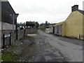
3

Skelgagh Road, Townagh
Heading north-west from Aghintain Road
Image: © Kenneth Allen
Taken: 24 Sep 2022
0.08 miles
4

Townagh Townland
Pictured along Skelgagh Road
Image: © Kenneth Allen
Taken: 24 Sep 2022
0.10 miles
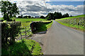
5
Skelgagh Road, Townagh
Looking north-west from Aghintain Road
Image: © Kenneth Allen
Taken: 12 Mar 2012
0.10 miles
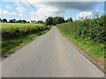
6
Aghintain Road
Heading WSW at Townagh
Image: © Kenneth Allen
Taken: 24 Sep 2022
0.10 miles
7

Skelgagh Road
Heading south-east at Townagh
Image: © Kenneth Allen
Taken: 24 Sep 2022
0.13 miles
9
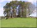
Rath at Townagh
No sign of the fairies!
Image: © Kenneth Allen
Taken: 23 Apr 2006
0.14 miles
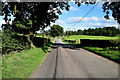
10
Aghintain Road, Carntall Beg / Prolusk
Heading WSW
Image: © Kenneth Allen
Taken: 18 Aug 2015
0.15 miles