IMAGES TAKEN NEAR TO
Ballagh Road, CLOGHER, BT76 0TQ
Introduction
This page details the photographs taken nearby to Ballagh Road, BT76 0TQ by members of the Geograph project.
The Geograph project started in 2005 with the aim of publishing, organising and preserving representative images for every square kilometre of Great Britain, Ireland and the Isle of Man.

There are currently over 7.5m images from over14,400 individuals and you can help contribute to the project by visiting https://www.geograph.org.uk
Image Map
Images are licensed for reuse under creativecommons.org/licenses/by-sa/2.0
Notes
- Clicking on the map will re-center to the selected point.
- The higher the marker number, the further away the image location is from the centre of the postcode.
Image Listing (9 Images Found)
Images are licensed for reuse under creativecommons.org/licenses/by-sa/2.0
Image
Details
Distance
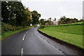
1
Ballagh Road, Carryclogher
In the background is the Clogher Valley cricket pavilion and pitch
Image: © Kenneth Allen
Taken: 21 Apr 2006
0.17 miles
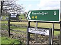
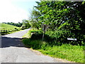
2
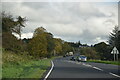
A4 Ballagh Road, Carryclogher
Heading ENE to Clogher
Image: © Kenneth Allen
Taken: 23 Jun 2015
0.17 miles
3
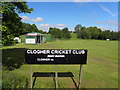
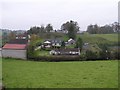
Clogher Cricket Club
Pictured along Ballagh Road
Image: © Kenneth Allen
Taken: 23 Jun 2015
0.19 miles
5
View from Clogher
Looking towards the west
Image: © Kenneth Allen
Taken: 4 Nov 2008
0.19 miles
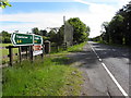
6
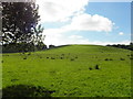
A low hill, Clogher Tenements
Looking east
Image: © Kenneth Allen
Taken: 23 Jun 2015
0.21 miles
7
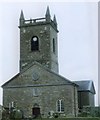
Clogher Cathedral, Co Tyrone
The present cathedral was built in 1744, when Bishop John Sterne was in charge.
Image: © Mervyn Greer
Taken: Unknown
0.22 miles
8
Ashfield Road, Carryclogher
Heading SSE from Ballagh Road
Image: © Kenneth Allen
Taken: 23 Jun 2015
0.23 miles