IMAGES TAKEN NEAR TO
Ashfield Road, CLOGHER, BT76 0HL
Introduction
This page details the photographs taken nearby to Ashfield Road, BT76 0HL by members of the Geograph project.
The Geograph project started in 2005 with the aim of publishing, organising and preserving representative images for every square kilometre of Great Britain, Ireland and the Isle of Man.

There are currently over 7.5m images from over14,400 individuals and you can help contribute to the project by visiting https://www.geograph.org.uk
Image Map
Images are licensed for reuse under creativecommons.org/licenses/by-sa/2.0
Notes
- Clicking on the map will re-center to the selected point.
- The higher the marker number, the further away the image location is from the centre of the postcode.
Image Listing (6 Images Found)
Images are licensed for reuse under creativecommons.org/licenses/by-sa/2.0
Image
Details
Distance
1
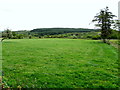
Ballyscally Townland
Looking east from Ashfield Road
Image: © Kenneth Allen
Taken: 17 Jun 2015
0.17 miles
2
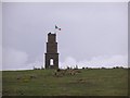
Brackenridge's Folly
Zooming in for a closer look - it can be seen from all round the Clogher Valley. It can be seen as far away as in Image For some reason or other I used to think it was called Trimble's Monument, which was what my grandparents referred to is as.
More on this at Image I found out that Brackenridge's skull used to lie about the monument and local boys played with it, not a very respectful treatment of the dead.
Image: © Kenneth Allen
Taken: 28 Apr 2008
0.19 miles
3
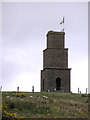
Brackenridge's Folly (aka Trimble's Monument)
This is Brackenridge's Folly, named after George Brackenridge who built it as his mausoleum so that "the squirearchy who had looked down on him during his lifetime were compelled to look up to him after his death".
George Charles Trimble,(1814-1879) was a prominent Barrister and landlord. Born a Presbyterian but later became a layman in Clogher Church of Ireland Cathedral. He was an aetiest but used church connections to have a vestige of respectability. He had illusions of grandeur and referred to himself as Lord Brackenridge, taking on the name from his grandmother. He was married to a daughter of the Bunberry family of Augher castle, and they had a son Upton, born in 1872 and died in 1927. He was a beau who lived off his father's money and spent time in Paris in 1927, where he married a French lady who spoke very little English. This proved to be a bit of a problem when the will had to be sorted out in later years. Brackenridge was dis-owned by the Trimbles and the upper classes. He lived at Ashfield House, built in 1840, near Clogher, the house is still standing and has changed hands about 10 times since (presently occipied by the Beattie family) More at Image]
Image: © Kenneth Allen
Taken: 28 Apr 2008
0.19 miles
4
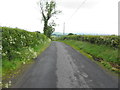
Ashfield Road, Ballyscally
Heading north
Image: © Kenneth Allen
Taken: 17 Jun 2015
0.23 miles
5
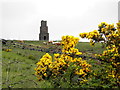
Whins, Ballyscally
Pictured along Corleaghan Road
In the background is Brackenridge's Folly
Image: © Kenneth Allen
Taken: 17 Jun 2015
0.23 miles
6
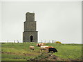
Brackenridge's Folly
Looking NNE from Corleaghan Road
Image: © Kenneth Allen
Taken: 17 Jun 2015
0.25 miles