IMAGES TAKEN NEAR TO
Fardross Road, CLOGHER, BT76 0HG
Introduction
This page details the photographs taken nearby to Fardross Road, BT76 0HG by members of the Geograph project.
The Geograph project started in 2005 with the aim of publishing, organising and preserving representative images for every square kilometre of Great Britain, Ireland and the Isle of Man.

There are currently over 7.5m images from over14,400 individuals and you can help contribute to the project by visiting https://www.geograph.org.uk
Image Map
Images are licensed for reuse under creativecommons.org/licenses/by-sa/2.0
Notes
- Clicking on the map will re-center to the selected point.
- The higher the marker number, the further away the image location is from the centre of the postcode.
Image Listing (6 Images Found)
Images are licensed for reuse under creativecommons.org/licenses/by-sa/2.0
Image
Details
Distance
1
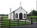
Fardross Orange Hall
Pictured along Fardross Road
See close-up of plaque here Image]
Image: © Kenneth Allen
Taken: 15 Jul 2015
0.02 miles
2
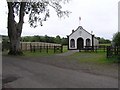
Fardross Orange Hall
In case you can't make out the writing on the plaque, it reads, "Erected in the Memory of Helen G Gledstanes, Fardross. For many years a staunch friend of Fardross L.O.L. No. 683 1936"
Image: © Kenneth Allen
Taken: 22 Jul 2008
0.03 miles
3
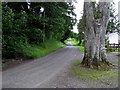
Road at Nurchoosy Scotch
Looking south
Image: © Kenneth Allen
Taken: 22 Jul 2008
0.03 miles
4
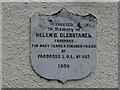
Plaque, Fardross Orange Hall
Pictured here Image]
Image: © Kenneth Allen
Taken: 15 Jul 2015
0.05 miles
5
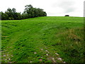
A low hill, Nurchossy Scotch
Looking north-west
Image: © Kenneth Allen
Taken: 15 Jul 2015
0.09 miles
6
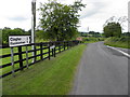
Fardross Road, Fardross Demesne
Heading north towards Clogher / Fivemiletown
Image: © Kenneth Allen
Taken: 15 Jul 2015
0.24 miles