IMAGES TAKEN NEAR TO
Derrygonnelly Road, ENNISKILLEN, BT74 8GA
Introduction
This page details the photographs taken nearby to Derrygonnelly Road, BT74 8GA by members of the Geograph project.
The Geograph project started in 2005 with the aim of publishing, organising and preserving representative images for every square kilometre of Great Britain, Ireland and the Isle of Man.

There are currently over 7.5m images from over14,400 individuals and you can help contribute to the project by visiting https://www.geograph.org.uk
Image Map
Images are licensed for reuse under creativecommons.org/licenses/by-sa/2.0
Notes
- Clicking on the map will re-center to the selected point.
- The higher the marker number, the further away the image location is from the centre of the postcode.
Image Listing (5 Images Found)
Images are licensed for reuse under creativecommons.org/licenses/by-sa/2.0
Image
Details
Distance
1
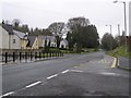
Monea Road
Looking north-west near Tullycreevy
Image: © Kenneth Allen
Taken: 2 Apr 2008
0.01 miles
2
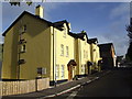
New houses at Tullycreevy
Catching the morning sunshine.
Image: © Jonathan Billinger
Taken: 26 Sep 2007
0.03 miles
3
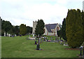
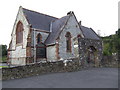
The Church of St. Molaise, Devenish parish
Situated at Monea by the B81.
Image: © Jonathan Billinger
Taken: 26 Sep 2007
0.23 miles
4
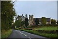
Church of St Molaise, Monea
Grade B listed.
Image: © N Chadwick
Taken: 17 Oct 2021
0.24 miles
5
Church of St. Molaise - west end
Image: © Jonathan Billinger
Taken: 26 Sep 2007
0.24 miles