IMAGES TAKEN NEAR TO
Derrygonnelly Road, ENNISKILLEN, BT74 8EA
Introduction
This page details the photographs taken nearby to Derrygonnelly Road, BT74 8EA by members of the Geograph project.
The Geograph project started in 2005 with the aim of publishing, organising and preserving representative images for every square kilometre of Great Britain, Ireland and the Isle of Man.

There are currently over 7.5m images from over14,400 individuals and you can help contribute to the project by visiting https://www.geograph.org.uk
Image Map
Images are licensed for reuse under creativecommons.org/licenses/by-sa/2.0
Notes
- Clicking on the map will re-center to the selected point.
- The higher the marker number, the further away the image location is from the centre of the postcode.
Image Listing (4 Images Found)
Images are licensed for reuse under creativecommons.org/licenses/by-sa/2.0
Image
Details
Distance
1
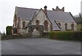
St Molaise Church of Ireland, Monea
It is in the Parish of Devenish and the Diocese of Clogher
Image: © Kenneth Allen
Taken: 2 Apr 2008
0.21 miles
2
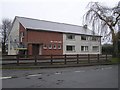
"the reade hall", Monea
It is located opposite the church.
Image: © Kenneth Allen
Taken: 2 Apr 2008
0.21 miles
3
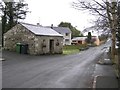
Monea, County Fermanagh
A quiet little village in the heart of the county and I couldn't find a pub!
Image: © Kenneth Allen
Taken: 2 Apr 2008
0.21 miles
4
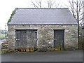
Forge, Monea
Unless some local suggests otherwise, I reckon that this was where the smithy laboured. Note the horse shoe-nailed onto the timber lintol.
Image: © Kenneth Allen
Taken: 2 Apr 2008
0.21 miles