IMAGES TAKEN NEAR TO
Lawnakilla Park, ENNISKILLEN, BT74 7JN
Introduction
This page details the photographs taken nearby to Lawnakilla Park, BT74 7JN by members of the Geograph project.
The Geograph project started in 2005 with the aim of publishing, organising and preserving representative images for every square kilometre of Great Britain, Ireland and the Isle of Man.

There are currently over 7.5m images from over14,400 individuals and you can help contribute to the project by visiting https://www.geograph.org.uk
Image Map
Images are licensed for reuse under creativecommons.org/licenses/by-sa/2.0
Notes
- Clicking on the map will re-center to the selected point.
- The higher the marker number, the further away the image location is from the centre of the postcode.
Image Listing (4 Images Found)
Images are licensed for reuse under creativecommons.org/licenses/by-sa/2.0
Image
Details
Distance
1
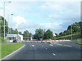
Approaching the traffic roundabout on the Irvinestown Road
Here traffic from the Cornagrade Road joins that of the Irvinestown Road.
Image: © Eric Jones
Taken: 27 Jul 2012
0.17 miles
2
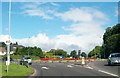
Roundabout on the Irvinestown Road
This is on the northern fringe of the city of Enniskillen.
Image: © Eric Jones
Taken: 27 Jul 2012
0.17 miles
3
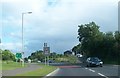
Minor road junction on the A32 (Irvinestown Road)
Image: © Eric Jones
Taken: 27 Jul 2012
0.18 miles
4
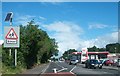
Esso Service Station on the Irvinestown Road, Enniskillen
Image: © Eric Jones
Taken: 27 Jul 2012
0.23 miles