IMAGES TAKEN NEAR TO
Elliott Place, ENNISKILLEN, BT74 7HQ
Introduction
This page details the photographs taken nearby to Elliott Place, BT74 7HQ by members of the Geograph project.
The Geograph project started in 2005 with the aim of publishing, organising and preserving representative images for every square kilometre of Great Britain, Ireland and the Isle of Man.

There are currently over 7.5m images from over14,400 individuals and you can help contribute to the project by visiting https://www.geograph.org.uk
Image Map
Images are licensed for reuse under creativecommons.org/licenses/by-sa/2.0
Notes
- Clicking on the map will re-center to the selected point.
- The higher the marker number, the further away the image location is from the centre of the postcode.
Image Listing (47 Images Found)
Images are licensed for reuse under creativecommons.org/licenses/by-sa/2.0
Image
Details
Distance
1

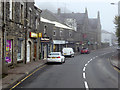
Coleshill Road, Enniskillen
Looking west from the Sligo Road
Image: © Kenneth Allen
Taken: 25 Jun 2009
0.09 miles
4

Inis Fold, Enniskillen
It is located off the Sligo Road
Image: © Kenneth Allen
Taken: 25 Jun 2009
0.11 miles
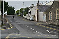
5
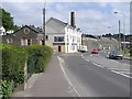
Sligo Road, Enniskillen
In the background is the DayToday shop
Image: © Kenneth Allen
Taken: 25 Jun 2009
0.11 miles
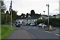
6
Sligo Road, Enniskillen
Bending north
Image: © Kenneth Allen
Taken: 25 Jun 2009
0.12 miles
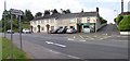
7
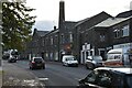
Former Scottish Cooperative Wholesale Society Factory
Grade B listed.
Image: © N Chadwick
Taken: 18 Oct 2021
0.13 miles
8
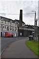
Former Scottish Cooperative Wholesale Society Factory
Grade B2 listed.
Image: © N Chadwick
Taken: 18 Oct 2021
0.13 miles
9

Factory, Enniskillen
It is located at Old Henry Street
Image: © Kenneth Allen
Taken: 25 Jun 2009
0.14 miles