IMAGES TAKEN NEAR TO
Drumclay Link, ENNISKILLEN, BT74 6DL
Introduction
This page details the photographs taken nearby to Drumclay Link, BT74 6DL by members of the Geograph project.
The Geograph project started in 2005 with the aim of publishing, organising and preserving representative images for every square kilometre of Great Britain, Ireland and the Isle of Man.

There are currently over 7.5m images from over14,400 individuals and you can help contribute to the project by visiting https://www.geograph.org.uk
Image Map
Images are licensed for reuse under creativecommons.org/licenses/by-sa/2.0
Notes
- Clicking on the map will re-center to the selected point.
- The higher the marker number, the further away the image location is from the centre of the postcode.
Image Listing (5 Images Found)
Images are licensed for reuse under creativecommons.org/licenses/by-sa/2.0
Image
Details
Distance
1
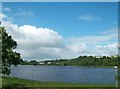
Race Course Lough, Enniskillen
This image was taken from Irvinestown Road.
http://www.prebait.com/coarse_fishing_venues/Northern_Ireland/Fermanagh/2625/RACECOURSE_LOUGH
Image: © Eric Jones
Taken: 27 Jul 2012
0.17 miles
2
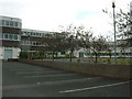
Collegiate School, Enniskillen, Fermanagh
Image: © Rosemary Nelson
Taken: 18 Jul 2005
0.18 miles
3
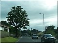
The Irvinestown Road (B32) at Enniskillen
The column in the distance is the Cole Monument. It commemorates Sir Galbraith Lowry-Cole (1772–1842), a Napoleonic British general and the son of the first Earl of Enniskillen. The top can be reached by climbing 108 steps inside the column. The column is very reminiscent of that of the Marquis of Anglesey at Llanfair P.G.
Image
Image: © Eric Jones
Taken: 27 Jul 2012
0.21 miles
4
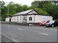
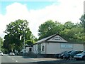
Gospel Hall, Enniskillen
It is located along the Irvinestown Road
Image: © Kenneth Allen
Taken: 19 Jun 2009
0.23 miles
5
Gospel Hall, Irvinestown Road, Enniskillen
Image: © Eric Jones
Taken: 27 Jul 2012
0.25 miles