IMAGES TAKEN NEAR TO
Belmore Street, ENNISKILLEN, BT74 6AB
Introduction
This page details the photographs taken nearby to Belmore Street, BT74 6AB by members of the Geograph project.
The Geograph project started in 2005 with the aim of publishing, organising and preserving representative images for every square kilometre of Great Britain, Ireland and the Isle of Man.

There are currently over 7.5m images from over14,400 individuals and you can help contribute to the project by visiting https://www.geograph.org.uk
Image Map
Images are licensed for reuse under creativecommons.org/licenses/by-sa/2.0
Notes
- Clicking on the map will re-center to the selected point.
- The higher the marker number, the further away the image location is from the centre of the postcode.
Image Listing (419 Images Found)
Images are licensed for reuse under creativecommons.org/licenses/by-sa/2.0
Image
Details
Distance
1
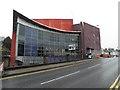
Mad hatter Caf?, Enniskillen
Pictured along Queen Elizabeth Road
Image: © Kenneth Allen
Taken: 10 Feb 2012
0.02 miles
2
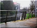
Erne River at the Clinton Centre
Flowing by Nugents Quay and Queen Elizabeth Road - and of course the Clinton Centre Hostel.
Image: © Dean Molyneaux
Taken: 28 Nov 2009
0.02 miles
3
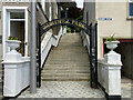
Entrance gates, Forthill park, Enniskillen
Pictured along Belmount Street
Image: © Kenneth Allen
Taken: 27 May 2022
0.02 miles
4
Nugents Entry, Enniskillen
Heading WNW. I thought that was also known as Queen Elizabeth Road
Image: © Kenneth Allen
Taken: 28 May 2010
0.02 miles
5
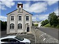
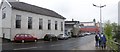
St Michael's Community Centre, Enniskillen
Beyond are the Convent Grammar School buildings
Image: © Kenneth Allen
Taken: 27 May 2022
0.02 miles
6
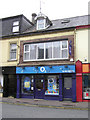
O2 Shop, Enniskillen
It is located in Belmore Street
Image: © Kenneth Allen
Taken: 19 Jun 2009
0.02 miles
7
The Clinton Centre from Queen Elizabeth Road
The Clinton Centre - a hostel/arts centre built on the site of the 1987 Poppy Day bomb - hiding here behind a tree at the corner of Queen Elizabeth Road and Belmore Street.
Image: © Dean Molyneaux
Taken: 28 Nov 2009
0.02 miles
8
The Clinton Centre Caf?, Enniskillen
It is located at Queen Elizabeth Road
Image: © Kenneth Allen
Taken: 6 Jun 2013
0.03 miles
9
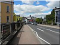
Queen Elizabeth Road, Enniskillen
Looking north-west;, the building on the left is the Presbyterian Hall
Image: © Kenneth Allen
Taken: 14 May 2009
0.03 miles
10
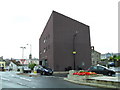
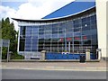
Clinton Centre
Voted the ugliest building in Northern Ireland - I dare not argue.
Image: © Dean Molyneaux
Taken: 29 Aug 2009
0.03 miles