IMAGES TAKEN NEAR TO
Old Sligo Road, ENNISKILLEN, BT74 5QR
Introduction
This page details the photographs taken nearby to Old Sligo Road, BT74 5QR by members of the Geograph project.
The Geograph project started in 2005 with the aim of publishing, organising and preserving representative images for every square kilometre of Great Britain, Ireland and the Isle of Man.

There are currently over 7.5m images from over14,400 individuals and you can help contribute to the project by visiting https://www.geograph.org.uk
Image Map
Images are licensed for reuse under creativecommons.org/licenses/by-sa/2.0
Notes
- Clicking on the map will re-center to the selected point.
- The higher the marker number, the further away the image location is from the centre of the postcode.
Image Listing (4 Images Found)
Images are licensed for reuse under creativecommons.org/licenses/by-sa/2.0
Image
Details
Distance
1
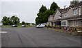
The Three Way Inn near Enniskillen
Inn on the Sligo Road near Enniskillen. There was a flush bracket bench mark (OSBM 3309 https://www.bench-marks.org.uk/bm68039 ) located here but it has been destroyed - probably when the building was rebuilt.
Image: © Rossographer
Taken: 30 Jun 2021
0.11 miles
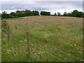
3
Granshagh Big
The white triangle in the distance is the gable of a house.
Image: © Kenneth Allen
Taken: 10 Jul 2007
0.15 miles
4
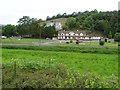
Cappog
Looking towards the Three Way Inn
Image: © Kenneth Allen
Taken: 10 Jul 2007
0.18 miles