IMAGES TAKEN NEAR TO
Samsonagh Road, ENNISKILLEN, BT74 5EJ
Introduction
This page details the photographs taken nearby to Samsonagh Road, BT74 5EJ by members of the Geograph project.
The Geograph project started in 2005 with the aim of publishing, organising and preserving representative images for every square kilometre of Great Britain, Ireland and the Isle of Man.

There are currently over 7.5m images from over14,400 individuals and you can help contribute to the project by visiting https://www.geograph.org.uk
Image Map
Images are licensed for reuse under creativecommons.org/licenses/by-sa/2.0
Notes
- Clicking on the map will re-center to the selected point.
- The higher the marker number, the further away the image location is from the centre of the postcode.
Image Listing (4 Images Found)
Images are licensed for reuse under creativecommons.org/licenses/by-sa/2.0
Image
Details
Distance
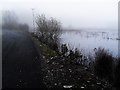
1

Fermanagh Floods 2009 (15 of 19): Mullygarry
After thirty-five consecutive days of rain in County Fermanagh throughout November 2009, the water levels on Lough Erne rose to 158ft above sea level (Ballyshannon). This was the highest since records began in 1956.
Here in the townland of Mullygarry, near Boho, not even the thick fog can hide the extent of the Sillees River overspill.
Back to:Image
Forward to:Image
Image: © Dean Molyneaux
Taken: 28 Nov 2009
0.13 miles
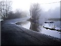
2
Fermanagh Floods 2009 (16 of 19): Mullygarry
After thirty-five consecutive days of rain in County Fermanagh throughout November 2009, the water levels on Lough Erne rose to 158ft above sea level (Ballyshannon). This was the highest since records began in 1956.
The road from Thompson's Bridge to Boho flooded at Samsonagh/Mullygarry - where the Sillees River burst its banks.
Back to: Image
Forward to: Image
Image: © Dean Molyneaux
Taken: 28 Nov 2009
0.19 miles
3
Fermanagh Floods 2009 (14 of 19): Mullygarry
After thirty-five consecutive days of rain in County Fermanagh throughout November 2009, the water levels on Lough Erne rose to 158ft above sea level (Ballyshannon). This was the highest since records began in 1956.
The Sillees River was also affected in the townlands of Samsonagh and Mullygarry - as can be seen here. A few days earlier the road had been closed completely.
Back to:Image
Forward to:Image
Image: © Dean Molyneaux
Taken: 28 Nov 2009
0.19 miles
4
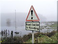
Fermanagh Floods 2009 (17 of 19): Samsonagh
After thirty-five consecutive days of rain in County Fermanagh throughout November 2009, the water levels on Lough Erne rose to 158ft above sea level (Ballyshannon). This was the highest since records began in 1956.
This ageing sign couldn't do much to prevent the Sillees River swamping the road at Samsonagh and Mullygarry.
Back to:Image
Forward to:Image
Image: © Dean Molyneaux
Taken: 28 Nov 2009
0.24 miles