IMAGES TAKEN NEAR TO
Samsonagh Road, ENNISKILLEN, BT74 5EB
Introduction
This page details the photographs taken nearby to Samsonagh Road, BT74 5EB by members of the Geograph project.
The Geograph project started in 2005 with the aim of publishing, organising and preserving representative images for every square kilometre of Great Britain, Ireland and the Isle of Man.

There are currently over 7.5m images from over14,400 individuals and you can help contribute to the project by visiting https://www.geograph.org.uk
Image Map
Images are licensed for reuse under creativecommons.org/licenses/by-sa/2.0
Notes
- Clicking on the map will re-center to the selected point.
- The higher the marker number, the further away the image location is from the centre of the postcode.
Image Listing (5 Images Found)
Images are licensed for reuse under creativecommons.org/licenses/by-sa/2.0
Image
Details
Distance
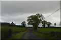
2
Road at Moybrone
Heading north-east to Enniskillen
Image: © Kenneth Allen
Taken: 6 Jul 2007
0.10 miles
3
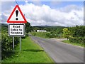
Road at Moybrone
A common occurrence in this part of the country.
Image: © Kenneth Allen
Taken: 6 Jul 2007
0.10 miles
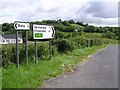
4
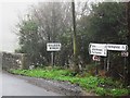
Signs at Croaghrim
In the townland of Croaghrim, besides Thompson's Bridge over the Sillees River.
Image: © Dean Molyneaux
Taken: 28 Nov 2009
0.20 miles
5
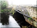
Thompson's Bridge, Killycat
This carries a road over the Sillees River and marks the boundary between the townlands of Croaghrim and Killycat.
Image: © Dean Molyneaux
Taken: 28 Nov 2009
0.21 miles