IMAGES TAKEN NEAR TO
Boho Road, ENNISKILLEN, BT74 5DS
Introduction
This page details the photographs taken nearby to Boho Road, BT74 5DS by members of the Geograph project.
The Geograph project started in 2005 with the aim of publishing, organising and preserving representative images for every square kilometre of Great Britain, Ireland and the Isle of Man.

There are currently over 7.5m images from over14,400 individuals and you can help contribute to the project by visiting https://www.geograph.org.uk
Image Map
Images are licensed for reuse under creativecommons.org/licenses/by-sa/2.0
Notes
- Clicking on the map will re-center to the selected point.
- The higher the marker number, the further away the image location is from the centre of the postcode.
Image Listing (12 Images Found)
Images are licensed for reuse under creativecommons.org/licenses/by-sa/2.0
Image
Details
Distance
1
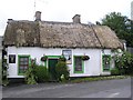
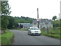
The Linnet Inn
It has a certain rural charm
Image: © Kenneth Allen
Taken: 6 Jul 2007
0.12 miles
2
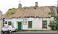
The Linnet Inn at Tullyholvin Lower
This thatched roof public house is over 200 years old and was once a coaching inn on the Enniskillen to Sligo road. The complex also includes a store, although today the range of goods sold and services offered are somewhat more limited than they were in the 1960's when the then proprietor, Eric Parker, composed a long poem extolling the virtues of the store, which included the following lines:-
"We have bacon,barley biscuits
And tea of the very best,
Furniture, lino, hardware,
Petrol, oil and all the rest,
We keep Guinness, Whisky, Brandy,
Ice cream and minerals too,
Cigarettes, tobacco, candy,
Drapery and Footwear new,
We are Funeral undertakers,
Frederick looks after that,
And boy! We're keen
for feeding stuff,
Ask Eamonn or Joe about that.
Image: © Eric Jones
Taken: 24 Jul 2012
0.13 miles
3
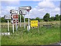
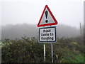
Road at Boho
I think the "h" is silent in Boho
Image: © Kenneth Allen
Taken: 6 Jul 2007
0.14 miles
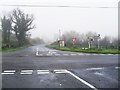
4
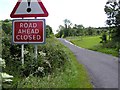
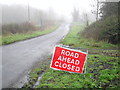
Road closed at Boho
Funnily enough I just came down that road.
Image: © Kenneth Allen
Taken: 6 Jul 2007
0.14 miles
5
Approaching Boho Cross Roads from the direction of Enniskillen
Image: © Eric Jones
Taken: 24 Jul 2012
0.18 miles
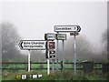
7
Boho Crossroads
Here The Graan to Belcoo road is met by roads from Derrygonnelly and Thompson's Bridge in the townland of Acres.
Boho is pronounced 'Boe'.
Image: © Dean Molyneaux
Taken: 28 Nov 2009
0.21 miles
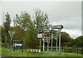
8
Signs at Boho
Boho (strictly pronounced 'Boe') is an area seven miles due west of Enniskillen on the back road to Belcoo (via The Graan). Derrygonnelly is the nearest proper village.
These signs is the tiny townland of Acres (itself only 11 acres in area).
Image: © Dean Molyneaux
Taken: 28 Nov 2009
0.21 miles
9
Fermanagh Floods 2009 (19 of 19): Boho
After thirty-five consecutive days of rain in County Fermanagh throughout November 2009, the water levels on Lough Erne rose to 158ft above sea level (Ballyshannon). This was the highest since records began in 1956.
This sign was certainly telling the truth as this road flooded badly in the townlands of Samsonagh and Mullygarry, a mile from Boho Crossroads.
Back to:Image
Image: © Dean Molyneaux
Taken: 28 Nov 2009
0.21 miles
10
Fermanagh Floods 2009 (18 of 19): Boho
After thirty-five consecutive days of rain in County Fermanagh throughout November 2009, the water levels on Lough Erne rose to 158ft above sea level (Ballyshannon). This was the highest since records began in 1956.
This road had reopened by the time I passed.
Back to:Image
Forward to:Image
Image: © Dean Molyneaux
Taken: 28 Nov 2009
0.22 miles