IMAGES TAKEN NEAR TO
Carrickbeg Road, ENNISKILLEN, BT74 5BZ

Introduction

This page details the photographs taken nearby to Carrickbeg Road, BT74 5BZ by members of the Geograph project.

The Geograph project started in 2005 with the aim of publishing, organising and preserving representative images for every square kilometre of Great Britain, Ireland and the Isle of Man.

There are currently over 7.5m images from over14,400 individuals and you can help contribute to the project by visiting https://www.geograph.org.uk

Image Map


Images are licensed for reuse under creativecommons.org/licenses/by-sa/2.0
Notes
  • Clicking on the map will re-center to the selected point.
  • The higher the marker number, the further away the image location is from the centre of the postcode.

Image Listing (19 Images Found)

Images are licensed for reuse under creativecommons.org/licenses/by-sa/2.0
Image
Details
Distance
1
Cows at Killyhommon
Looking at view isn't their priority
Image: © Kenneth Allen Taken: 6 Jul 2007
0.08 miles
2
Killyhommon cow.
It must be great to be surrounded by grass. The Crannog in Ross Lough in the distance can be seen on the right.
Image: © Kenneth Allen Taken: 6 Jul 2007
0.08 miles
3
Ruin at Killyhommon
Long since abandoned
Image: © Kenneth Allen Taken: 6 Jul 2007
0.08 miles
4
The Diamond, Boho
The Diamond is the square outside the Catholic chapel and in the past had two shops. In January 1895, Michael Davitt, the land reform campaigner, addressed a huge crowd of tenant farmers on a field adjoining the Diamond - and which is still known as Davitt's Field. The Diamond is in the townland of Aghamore.
Image: © Eric Jones Taken: 24 Jul 2012
0.15 miles
5
Telephone Call Box, Boho
A sorry looking K6 red telephone box in Boho, Fermanagh.
Image: © Rossographer Taken: 14 Mar 2015
0.16 miles
6
Postbox, Boho
Post mounted Elizabeth II postbox (BT74 50) in Boho, Fermanagh.
Image: © Rossographer Taken: 14 Mar 2015
0.16 miles
7
The car park of the Sacred Heart Church at The Diamond
Image: © Eric Jones Taken: 24 Jul 2012
0.16 miles
8
The Sacred Heart Catholic Church, Boho
Situated in the townland of Toneel North, this one of the few Catholic chapels in Ireland to stand on land which was in constant use for Christian worship from the days of the early Celtic Church to the Reformation. After the Reformation such sites came into the ownership of the Protestant Church of Ireland, but because the Boho area attracted few Protestant planters the pre-Reformation church was allowed to become dilapidated while the local population worship surreptitiously at Mass stones in the area. When the Church of Ireland church was built in the late 1799s, some its stones were used in that building. With the relaxation of the Penal Laws the Catholics were drawn back to the old site and a new church built there for the sum of £20. This was replaced by the present building in 1913. The church is said to have been founded by the sixth century St Faber. In 2018, the shortage of priests led to masses being celebrated here only every other Sunday. https://www.bbc.co.uk/news/uk-northern-ireland-45929249
Image: © Eric Jones Taken: 24 Jul 2012
0.20 miles
9
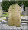
Gravestone, Boho
Gravestone in the churchyard of Sacred Heart Church, Toneel North, Boho Image This is the gravestone of Owen McManus who died, aged 61, on the 25th November 1763.
Image: © Rossographer Taken: 14 Mar 2015
0.21 miles
10
Sacred Heart Church, Boho
RC church at Boho in Fermanagh. Previously seen and described in detail at Image
Image: © Rossographer Taken: 14 Mar 2015
0.21 miles