IMAGES TAKEN NEAR TO
Carrickbeg Road, ENNISKILLEN, BT74 5AP
Introduction
This page details the photographs taken nearby to Carrickbeg Road, BT74 5AP by members of the Geograph project.
The Geograph project started in 2005 with the aim of publishing, organising and preserving representative images for every square kilometre of Great Britain, Ireland and the Isle of Man.

There are currently over 7.5m images from over14,400 individuals and you can help contribute to the project by visiting https://www.geograph.org.uk
Image Map
Images are licensed for reuse under creativecommons.org/licenses/by-sa/2.0
Notes
- Clicking on the map will re-center to the selected point.
- The higher the marker number, the further away the image location is from the centre of the postcode.
Image Listing (1 Images Found)
Images are licensed for reuse under creativecommons.org/licenses/by-sa/2.0
Image
Details
Distance
1
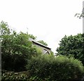
The former RUC Barracks at Carngreen
This barracks was manned from 1860 to 1937, first by the RIC and later, after 1922, by the RUC. It had a complement of six - five constables and a sergeant. It is now a private house. Today, policing in Boho is the responsibility of the Fermanagh West Community Policing team of the PSNI based at Enniskillen.
Image: © Eric Jones
Taken: 24 Jul 2012
0.12 miles