IMAGES TAKEN NEAR TO
Belview Road, ENNISKILLEN, BT74 4JH
Introduction
This page details the photographs taken nearby to Belview Road, BT74 4JH by members of the Geograph project.
The Geograph project started in 2005 with the aim of publishing, organising and preserving representative images for every square kilometre of Great Britain, Ireland and the Isle of Man.

There are currently over 7.5m images from over14,400 individuals and you can help contribute to the project by visiting https://www.geograph.org.uk
Image Map
Images are licensed for reuse under creativecommons.org/licenses/by-sa/2.0
Notes
- Clicking on the map will re-center to the selected point.
- The higher the marker number, the further away the image location is from the centre of the postcode.
Image Listing (2 Images Found)
Images are licensed for reuse under creativecommons.org/licenses/by-sa/2.0
Image
Details
Distance
1
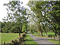
The Ring road
This lane takes you to the viewpoint on the opposite side of the River Erne to Bellanaleck. The township is known as Ring.
Image: © Jonathan Billinger
Taken: 26 Sep 2007
0.11 miles
2
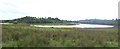
Big bend in the River Erne
Possibly an extension of the Upper Lough to the south of Enniskillen, nevertheless beautiful countryside.
Image: © Jonathan Billinger
Taken: 26 Sep 2007
0.22 miles