IMAGES TAKEN NEAR TO
Derryvullan Road, ENNISKILLEN, BT74 4HT
Introduction
This page details the photographs taken nearby to Derryvullan Road, BT74 4HT by members of the Geograph project.
The Geograph project started in 2005 with the aim of publishing, organising and preserving representative images for every square kilometre of Great Britain, Ireland and the Isle of Man.

There are currently over 7.5m images from over14,400 individuals and you can help contribute to the project by visiting https://www.geograph.org.uk
Image Map
Images are licensed for reuse under creativecommons.org/licenses/by-sa/2.0
Notes
- Clicking on the map will re-center to the selected point.
- The higher the marker number, the further away the image location is from the centre of the postcode.
Image Listing (6 Images Found)
Images are licensed for reuse under creativecommons.org/licenses/by-sa/2.0
Image
Details
Distance
1
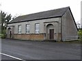
Church of Ireland Hall, Tamlaght
It is the opposite side of the road to the church and in a different square
Image: © Kenneth Allen
Taken: 12 Nov 2008
0.15 miles
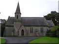
2
Church of Ireland, Tamlaght
Pictured near Fyagh
Image: © Kenneth Allen
Taken: 5 Nov 2012
0.15 miles
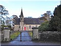
3
Derryvullan South Church of Ireland
It is in the Diocese of Clogher and in the Parish of Saint Tighernach
Image: © Kenneth Allen
Taken: 27 Aug 2008
0.16 miles
4
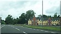
Housing estate on Enniskillen Road, Tamlaght
This image was taken from the A4 (Belfast Road).
Image: © Eric Jones
Taken: 24 Jul 2012
0.21 miles
5
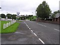
Road at Killyreagh
Heading north near Tamlaght
Image: © Kenneth Allen
Taken: 27 Aug 2008
0.21 miles
6
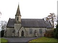
Derryvullan South Church of Ireland
I must be going senile, I pictured this church in August, ah well it confirms that it hasn't moved Image]
Image: © Kenneth Allen
Taken: 12 Nov 2008
0.22 miles