IMAGES TAKEN NEAR TO
Annadale Crescent, BELFAST, BT7 3ND
Introduction
This page details the photographs taken nearby to Annadale Crescent, BT7 3ND by members of the Geograph project.
The Geograph project started in 2005 with the aim of publishing, organising and preserving representative images for every square kilometre of Great Britain, Ireland and the Isle of Man.

There are currently over 7.5m images from over14,400 individuals and you can help contribute to the project by visiting https://www.geograph.org.uk
Image Map
Images are licensed for reuse under creativecommons.org/licenses/by-sa/2.0
Notes
- Clicking on the map will re-center to the selected point.
- The higher the marker number, the further away the image location is from the centre of the postcode.
Image Listing (238 Images Found)
Images are licensed for reuse under creativecommons.org/licenses/by-sa/2.0
Image
Details
Distance
1
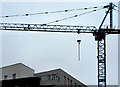
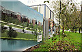
"The Embankment", Belfast (2)
A crane, idle over the Christmas and New Year break, on "The Embankment" site.
Image: © Albert Bridge
Taken: 30 Dec 2010
0.02 miles
2
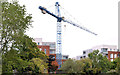
"The Embankment" crane, Belfast
The disused (or unused) crane, at the unfinished “Embankment” development, seen from the towpath near the Lockview Road.
Image: © Albert Bridge
Taken: 16 Sep 2013
0.02 miles
3
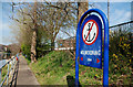
"No mooring" sign, Belfast
A “no mooring” sign by the Lagan beside the Annadale Embankment. There are electricity cables Image in the vicinity.
Image: © Albert Bridge
Taken: 12 Apr 2010
0.03 miles
4
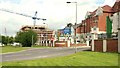
"The Embankment", Belfast (1)
Two developments along the Annadale Embankment – “The Embankment” apartments (at the crane) under construction and “Lagan Way” apartments and town houses on the right.
Image: © Albert Bridge
Taken: 5 Jun 2009
0.03 miles
5

Anglers path, River Lagan, Belfast
20 years ago anyone suggesting that this stretch of the Lagan would have provision for anglers might have expected a visit from the “men in the white coats”. Various species are now found between the weirs Image and Image There are stands on the eastern side of the river in the limited space between the Lagan (right) and the Annadale Embankment. There is no continuous path on this side but there are short stretches leading to the stands – some are a bit overgrown.
Image: © Albert Bridge
Taken: 5 Jun 2009
0.03 miles
6
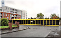
"The Embankment", Belfast (5)
Some of the developer’s advertising, around the now-vacant site, facing the Annadale Embankment. Most of it remains but with the sales information covered.
Image: © Albert Bridge
Taken: 14 Sep 2011
0.04 miles
7
"The Embankment", Belfast (3)
The completed and occupied part of the development is on the left. The site, behind the black and yellow hoarding, is vacant. The crane Image remains (top left). The view is from Annadale Green to Annadale Crescent.
Image: © Albert Bridge
Taken: 14 Sep 2011
0.04 miles
8
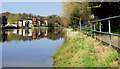
The River Lagan at Annadale, Belfast (1)
The view downstream, towards the Stranmillis Wharf apartments Image and the Governor’s Bridge, from the path Image by the Annadale Embankment. Continue to Image
Image: © Albert Bridge
Taken: 12 Apr 2010
0.05 miles
9
New apartments, Annadale, Belfast (November 2017)
New apartments, under construction, between the Annadale Embankment and Annadale Drive – previously part of the abandoned Embankment site.
Image: © Albert Bridge
Taken: 5 Nov 2017
0.05 miles
10
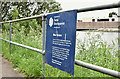
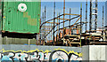
Department for Social Development sign, River Lagan, Belfast (June 2016)
The number of Departments was reduced after the 2016 Assembly election. The DSD is now part of the new Department for Communities which retains responsibility for navigation on the River Lagan. This sign is below the Annadale Embankment.
Image: © Albert Bridge
Taken: 17 Jun 2016
0.05 miles