IMAGES TAKEN NEAR TO
Rossmore Avenue, BELFAST, BT7 3HB
Introduction
This page details the photographs taken nearby to Rossmore Avenue, BT7 3HB by members of the Geograph project.
The Geograph project started in 2005 with the aim of publishing, organising and preserving representative images for every square kilometre of Great Britain, Ireland and the Isle of Man.

There are currently over 7.5m images from over14,400 individuals and you can help contribute to the project by visiting https://www.geograph.org.uk
Image Map
Images are licensed for reuse under creativecommons.org/licenses/by-sa/2.0
Notes
- Clicking on the map will re-center to the selected point.
- The higher the marker number, the further away the image location is from the centre of the postcode.
Image Listing (138 Images Found)
Images are licensed for reuse under creativecommons.org/licenses/by-sa/2.0
Image
Details
Distance
1
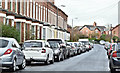
Florenceville Avenue, Belfast (March 2017)
A late-19th century street, mainly of terrace houses, on the south western side of the Ormeau Road. There were three houses in 1890 and 21 in 1901. Previously seen in Image (February 2012). Many of the streets, locally, are notable for the number of tightly-parked cars.
Image: © Albert Bridge
Taken: 31 Mar 2017
0.02 miles
2
Rossmore Avenue, off the Upper Ormeau Road
This another residential street, with good houses of late Victorian vintage.
Image: © Eric Jones
Taken: 17 Feb 2015
0.03 miles
3
Ardmore Avenue off Ormeau Road
This is a residential street with new housing developments.
Image: © Eric Jones
Taken: 15 Feb 2012
0.03 miles
4
Florenceville Avenue
This is a residential street off the Ormeau Road.
Image: © Eric Jones
Taken: 15 Feb 2012
0.03 miles
5
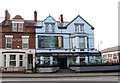
The Parador Inn, Upper Ormeau Road
The Parador Inn, is one of seven well known Belfast and Co Down watering holes purchased by the Derry GAA legends Henry and Seamus Downey in October 2013.
http://www.belfasttelegraph.co.uk/business/news/former-gaa-stars-snap-up-belfast-bars-ryans-molly-browns-the-parador-and-apartment-29651109.html
Image: © Eric Jones
Taken: 17 Feb 2015
0.04 miles
6
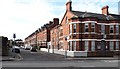
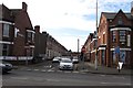
Ardmore Medical Centre
This is located at the junction of Ardmore Avenue and the Upper Ormeau Road.
Image: © Eric Jones
Taken: 17 Feb 2015
0.05 miles
7
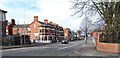
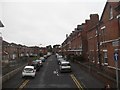
View northwards along Ormeau Road
The large house on the corner is the Ardmore Medical Centre.
Image
Image: © Eric Jones
Taken: 17 Feb 2015
0.05 miles
8
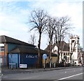
Rosario Youth Centre, Upper Ormeau Road
Rosario YC has a reputation built over one hundred years of producing notable football (soccer) teams. Today they play at the former cricket grounds now known as the Ulidia Playing Fields.
Image]
http://www.rosario-fc.com/
Image: © Eric Jones
Taken: 17 Feb 2015
0.06 miles
9
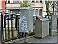
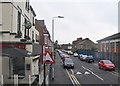
Drop box, Ormeau Road, Belfast (March 2017)
An elongated drop box close to Whitehall Parade (background).
Image: © Albert Bridge
Taken: 31 Mar 2017
0.06 miles
10
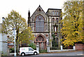
Former Holy Rosary church, Ballynafeigh, Belfast
See Image (November 2005). The former Our lady of the Holy Rosary Roman Catholic church at 350 Ormeau Road, completed in 1898, in what then countryside, to a design JJ O’Shea. Listed as HB26/01/021 and also on the official “at risk” register.
Vacant and now offered for sale (along with the former presbytery (348 Image). Described by the agents as follows: “The properties comprise a former Church building and an adjacent two and a half storey detached house which is now in derelict state. The church is graded as a B1 listed building while the detached house has no listed status whatsoever. The church is Grade B listed with effect from 19th August 1986. To the rear of the church is a former garden/orchard, which may be used as a car park for future development. Planning: The church has had planning permission for a change of use to a museum, art gallery, coffee shop, bistro, offices and small creche. Reference: Z/1997/0772”.
This photograph appears as a matter of record only. I have no connection with any of the parties involved in the sale.
Image: © Albert Bridge
Taken: 19 Oct 2012
0.06 miles