IMAGES TAKEN NEAR TO
Ormeau Road, BELFAST, BT7 3GB
Introduction
This page details the photographs taken nearby to Ormeau Road, BT7 3GB by members of the Geograph project.
The Geograph project started in 2005 with the aim of publishing, organising and preserving representative images for every square kilometre of Great Britain, Ireland and the Isle of Man.

There are currently over 7.5m images from over14,400 individuals and you can help contribute to the project by visiting https://www.geograph.org.uk
Image Map
Images are licensed for reuse under creativecommons.org/licenses/by-sa/2.0
Notes
- Clicking on the map will re-center to the selected point.
- The higher the marker number, the further away the image location is from the centre of the postcode.
Image Listing (158 Images Found)
Images are licensed for reuse under creativecommons.org/licenses/by-sa/2.0
Image
Details
Distance
1
![Ormeau Bakery redevelopment, Belfast [2]](https://s1.geograph.org.uk/photos/67/08/670877_32e52a04_120x120.jpg)
Ormeau Bakery redevelopment, Belfast [2]
Clearly somebody does not agree with the redevelopment of the Ormeau Bakery!
Image: © Rossographer
Taken: 28 Jan 2008
0.03 miles
2
![Ormeau Bakery redevelopment, Belfast [1]](https://s0.geograph.org.uk/photos/67/08/670876_04685661_120x120.jpg)
Ormeau Bakery redevelopment, Belfast [1]
I used to love the smell of baking bread whilst walking past this bakery on the Ormeau Road in Belfast. Sadly it is no more, closed and being redeveloped for apartments.
Image: © Rossographer
Taken: 28 Jan 2008
0.03 miles
3
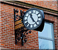
The Ormeau Bakery clock, Belfast
See Image The (presumably) original clock. It can be seen on the building, before redevelopment, in Image
Image: © Albert Bridge
Taken: 23 Mar 2010
0.03 miles
4
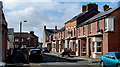
Derlett Street, Belfast
Late Victorian street running from Ava Avenue to Blackwood Street (background). The north western side (right) has been partly re-built.
Image: © Albert Bridge
Taken: 15 Sep 2010
0.03 miles
6
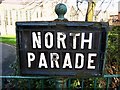
Sign, North Parade Belfast
Street sign for North Parade, Belfast, which runs from the Ormeau Road to Ravenhill Road.
Image: © Rossographer
Taken: 28 Jan 2008
0.04 miles
7
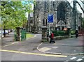
The main entrance to the Cooke Centenary Presbyterian Church, Ormeau Road
This church was built in the 1890s.
Image: © Eric Jones
Taken: 27 Apr 2012
0.04 miles
8
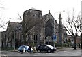
Cooke Centenary Church on Ormeau Road
This is a Presbyterian church. The Ormeau Road area south of the Ormeau Bridge is a culturally mixed area with a higher Protestant percentage than the Lower Ormeau Road. The church is located at the junction of Park Road and Ormeau Road.
Image: © Eric Jones
Taken: 17 Feb 2015
0.04 miles
9
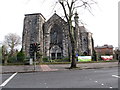
Cooke Centenary Church
Located in the Middle Ormeau Road area, it stands between the middle class Park Road area and the Annadale Protestant working class housing estate.
Image
Image: © Eric Jones
Taken: 17 Feb 2015
0.04 miles
10
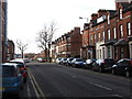
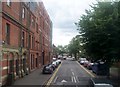
View West along Ava Street
This is a residential street off Ormeau Road.
Image: © Eric Jones
Taken: 17 Feb 2015
0.05 miles