IMAGES TAKEN NEAR TO
Haypark Gardens, BELFAST, BT7 3FL
Introduction
This page details the photographs taken nearby to Haypark Gardens, BT7 3FL by members of the Geograph project.
The Geograph project started in 2005 with the aim of publishing, organising and preserving representative images for every square kilometre of Great Britain, Ireland and the Isle of Man.

There are currently over 7.5m images from over14,400 individuals and you can help contribute to the project by visiting https://www.geograph.org.uk
Image Map
Images are licensed for reuse under creativecommons.org/licenses/by-sa/2.0
Notes
- Clicking on the map will re-center to the selected point.
- The higher the marker number, the further away the image location is from the centre of the postcode.
Image Listing (58 Images Found)
Images are licensed for reuse under creativecommons.org/licenses/by-sa/2.0
Image
Details
Distance
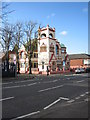
1
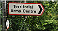
Red-bordered road sign, Belfast
Signs with red borders denote MoD establishments – in this case a TA centre.
Image: © Albert Bridge
Taken: 15 Sep 2010
0.11 miles
3
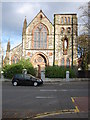
Holy Rosary Church
This Catholic Church is no longer in use.
Image: © Brian Shaw
Taken: 1 Nov 2005
0.11 miles
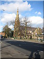
4
St. Jude's Parish Church
This Church of Ireland Parish Church was consecrated in 1873.
Image: © Brian Shaw
Taken: 1 Nov 2005
0.11 miles
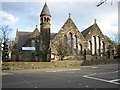
5
Ballynafeigh Methodist Church
This Church in the Queen anne revival style was built in 1898.
Image: © Brian Shaw
Taken: 1 Nov 2005
0.11 miles
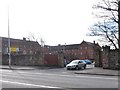
6
Roseville House Hostel at the back of the Lys Marie Nunnery
This building now houses homeless families.
Image: © Eric Jones
Taken: 15 Feb 2012
0.18 miles
7
Ardmore Avenue off Ormeau Road
This is a residential street with new housing developments.
Image: © Eric Jones
Taken: 15 Feb 2012
0.19 miles
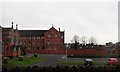
8
The Good Shepherd Centre, Upper Ormeau Road
This sprawling brick built campus of Victorian buildings was erected as a convent for the Sisters of the Good Shepherd an order which in Belfast, as in the rest of Ireland, ran the infamous Magdalen Laundries. Here "fallen women" were used as cheap labour in laundering the dirty washing of Belfast's upper and middle classes. Belfast also had equally notorious Church of Ireland and Presbyterian Magdalen laundries which "cared" for Protestant unmarried mothers. The Magdalen Laundry at Belfast's Good Shepherd Convent remained in existence until 1977.
http://www.huffingtonpost.co.uk/patrick-corrigan/magdalene-laundries-north-irelands-shame_b_2712206.html
Image: © Eric Jones
Taken: 17 Feb 2015
0.19 miles
9
View across the Ormeau Road to Florenceville Drive
The building on the left is the Whitewell Methodist Church.
Image: © Eric Jones
Taken: 17 Feb 2015
0.19 miles
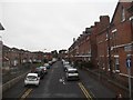
10
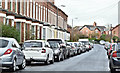
Florenceville Avenue, Belfast (March 2017)
A late-19th century street, mainly of terrace houses, on the south western side of the Ormeau Road. There were three houses in 1890 and 21 in 1901. Previously seen in Image (February 2012). Many of the streets, locally, are notable for the number of tightly-parked cars.
Image: © Albert Bridge
Taken: 31 Mar 2017
0.19 miles