IMAGES TAKEN NEAR TO
Haywood Avenue, BELFAST, BT7 3EU
Introduction
This page details the photographs taken nearby to Haywood Avenue, BT7 3EU by members of the Geograph project.
The Geograph project started in 2005 with the aim of publishing, organising and preserving representative images for every square kilometre of Great Britain, Ireland and the Isle of Man.

There are currently over 7.5m images from over14,400 individuals and you can help contribute to the project by visiting https://www.geograph.org.uk
Image Map
Images are licensed for reuse under creativecommons.org/licenses/by-sa/2.0
Notes
- Clicking on the map will re-center to the selected point.
- The higher the marker number, the further away the image location is from the centre of the postcode.
Image Listing (150 Images Found)
Images are licensed for reuse under creativecommons.org/licenses/by-sa/2.0
Image
Details
Distance
1
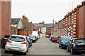
Gipsy Street, Belfast
A short street, of early 20th century terrace houses, off Sunnyside Street.
Image: © Albert Bridge
Taken: 23 Mar 2010
0.02 miles
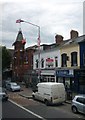
2
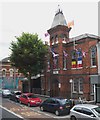
Ballynafeigh Orange Hall, Ormeau Road
Ballinafeigh Orange Hall was built in the 1890s.
http://www.ballynafeighorangehall.co.uk/files/Part-Three.pdf
Image: © Eric Jones
Taken: 21 Jul 2014
0.03 miles
3
Ballynafeigh Orange Hall on the Ormeau Road
Ormeau Road runs through both Nationalist and Loyalist areas and communal friction was common during the annual Marching Season. In the 1990s clashes would occur in the vicinity of the Ormeau Bridge with the Nationalists of the Lower Ormeau Road attempting to stop Orange Order feeder parades originating in the Ballynafeigh Loyalist enclaves from making their way towards the city centre along the Lower Ormeau Road.
Image: © Eric Jones
Taken: 28 Mar 2017
0.03 miles
4
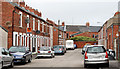
Primrose Street, Belfast
A short late-Victorian street off Sunnyside Street Image Note for genealogists: there was another Primrose Street (off the Crumlin Road).
Image: © Albert Bridge
Taken: 14 Sep 2010
0.04 miles
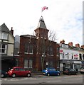
5
Ormeau Road near Ballynafeigh Orange Hall
The Orange Hall is the Gothic style building surmounted by a large Union Flag.
Image: © Eric Jones
Taken: 21 Jul 2014
0.04 miles
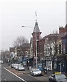
7
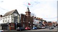
Block of buildings on Ormeau Road between Heyward Avenue and Deramore Road
The building sporting the large Union Flag is the Ballynafeigh Orange Hall.
Image: © Eric Jones
Taken: 17 Feb 2015
0.04 miles
8
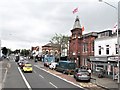
Ballynafeigh Orange Hall on the Ormeau Road
Ormeau Road runs through both Nationalist and Loyalist areas and communal friction was common during the annual Marching Season. In the 1990s clashes would occur in the vicinity of the Ormeau Bridge with the Nationalists of the Lower Ormeau Road attempting to stop Orange Order feeder parades originating in the Ballynafeigh Loyalist enclaves from making their way towards the city centre along the Lower Ormeau Road.
Image: © Eric Jones
Taken: 30 Jun 2017
0.04 miles
9
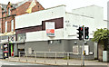
Nos 423-427 Ormeau Road, Belfast (April 2018)
The sign advises that the premises are suitable for refurbishment or redevelopment.
Image: © Albert Bridge
Taken: 13 Apr 2018
0.04 miles
10
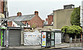
Nos 423-427 Ormeau Road, Belfast (October 2019)
Now demolished.
Image: © Albert Bridge
Taken: 5 Oct 2019
0.04 miles