IMAGES TAKEN NEAR TO
Kimberley Street, BELFAST, BT7 3DY
Introduction
This page details the photographs taken nearby to Kimberley Street, BT7 3DY by members of the Geograph project.
The Geograph project started in 2005 with the aim of publishing, organising and preserving representative images for every square kilometre of Great Britain, Ireland and the Isle of Man.

There are currently over 7.5m images from over14,400 individuals and you can help contribute to the project by visiting https://www.geograph.org.uk
Image Map
Images are licensed for reuse under creativecommons.org/licenses/by-sa/2.0
Notes
- Clicking on the map will re-center to the selected point.
- The higher the marker number, the further away the image location is from the centre of the postcode.
Image Listing (139 Images Found)
Images are licensed for reuse under creativecommons.org/licenses/by-sa/2.0
Image
Details
Distance
1
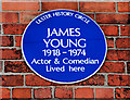
James Young plaque, Belfast
The inscription on the plaque and the description in the Ulster History Circle’s website http://www.ulsterhistory.co.uk/jamesyoung.htm are understatements when describing the late James Young.
More than just a Belfast Stanley Baxter, his portrayals of the lady from Cheeryvelley, the trade union official, the window cleaner and “Orange Lily” caught the public’s attention. He became an institution not understood outside Northern Ireland. In the days before “coming out” became fashionable he kept his personal life a secret. He was funny but perceptive, entertaining but thought provoking when delivering a political homily. Some of his performances may be seen on Youtube.
The plaque is on a house in Fernwood Street Image, off the Ormeau Road.
Image: © Albert Bridge
Taken: 15 Sep 2010
0.04 miles
2
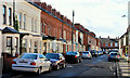
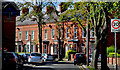
Fernwood Street, Belfast (1)
Part of an intricate pattern of streets, between the Ormeau Road and Sunnyside Street, Fernwood Street consists of terrace houses dating from the early 20th century. It runs from Blackwood Street (behind me) to Ava Street. See also Image
Image: © Albert Bridge
Taken: 15 Sep 2010
0.05 miles
3
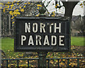
Street sign, Belfast
Street sign on North Parade, Belfast (last seen in 2008 Image). Similar signs in Belfast have been listed - https://www.belfasttelegraph.co.uk/news/northern-ireland/signs-pointing-way-to-bygone-belfast-to-get-historic-listing-36882731.html - but not this example.
Image: © Rossographer
Taken: 16 Dec 2021
0.05 miles
4
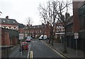
The northern end of Rushfield Avenue from the Ormeau Road
This one of many Victorian residential streets behind Ormeau Road.
Image
Image: © Eric Jones
Taken: 12 Mar 2011
0.07 miles
5
![Ormeau Bakery redevelopment, Belfast [1]](https://s0.geograph.org.uk/photos/67/08/670876_04685661_120x120.jpg)
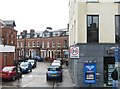
Ormeau Bakery redevelopment, Belfast [1]
I used to love the smell of baking bread whilst walking past this bakery on the Ormeau Road in Belfast. Sadly it is no more, closed and being redeveloped for apartments.
Image: © Rossographer
Taken: 28 Jan 2008
0.07 miles
6
Deramore Avenue, Belfast (2)
See Image The other end of the street – at the Ormeau Road.
Image: © Albert Bridge
Taken: 15 Sep 2010
0.07 miles
7
The north-eastern end of Deramore Avenue
Image: © Eric Jones
Taken: 15 Feb 2012
0.07 miles
8
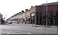
Deramore Avenue, Middle Ormeau Road
This is an avenue of late Victorian houses.
Image: © Eric Jones
Taken: 17 Feb 2015
0.07 miles
9
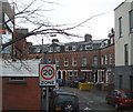
The entrance into Rushfield Avenue from Ormeau Road
Image: © Eric Jones
Taken: 15 Feb 2012
0.08 miles
10
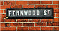
Fernwood Street, Belfast (2)
See Image The tiled sign, without the postal district number, at the Blackwood Street end.
Image: © Albert Bridge
Taken: 15 Sep 2010
0.08 miles